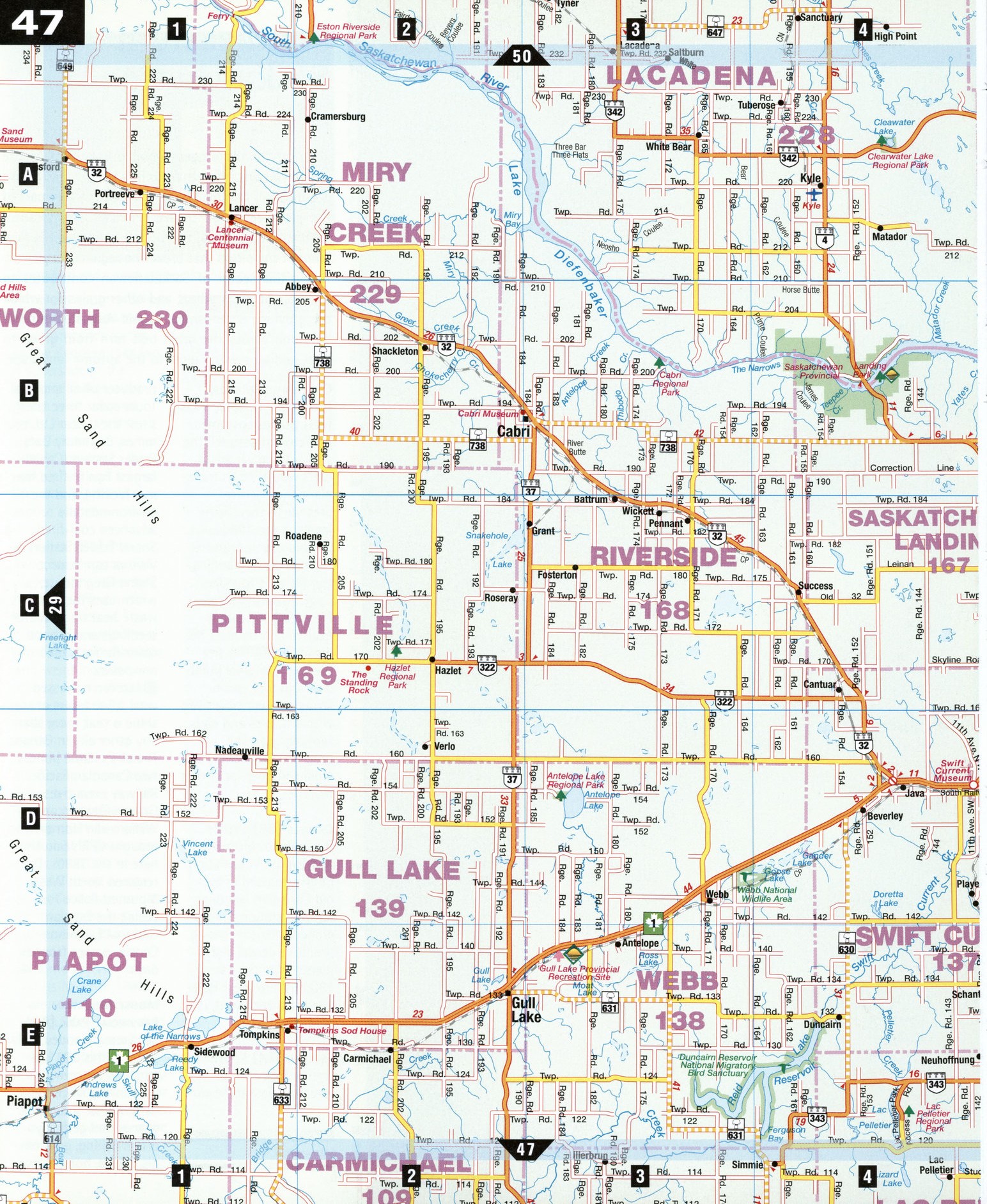
Road map Swift Current city surrounding area (Saskatchewan, Canada)
Road map of Swift Current city area (Canada)
Map of Swift Current city area. Detailed map of the highway and local roads of Swift Current Area with cities and towns.
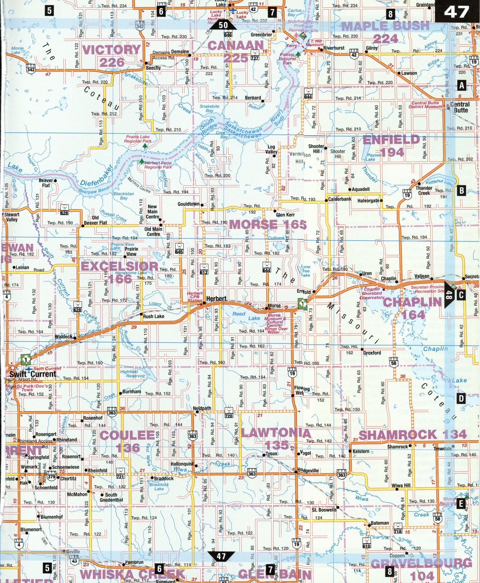
Large scale road map of Swift Current city area (Canada)
Map of Swift Current city area. Detailed map of the highway and local roads of Swift Current Area with cities and towns.
Swift Current Area
Acrossroads for southwestern Saskatchewan, Swift Current is an ideal base for exploring this region's two major attractions. North of Swift Current, Highway 4 leads to Saskatchewan Landing Provincial Park, on the shores of Lake Diefenbaker. The largest body of water in this arid region, the man-made lake was an eight-year project, completed in 1967. South of Swift Current, Highway 4 leads to Val Marie and the west block of Grasslands National Park, a park-in-progress that preserves a tract of Saskatchewan's pristine short-grass prairie.
Chaplin [c8] More than 30 species of shorebirds find refuge along the mudflats at the Western Hemispheric Shorebird Reserve on Chaplin Lake, just west of town. The interpretive center-with viewing tower and walking trails-is a starting point for tours of nearby attractions, including bison ranches. (SHwy 19 leads north from Chaplin to River-hurst (see below) and other sites at the east end of Lake Diefenbaker.
Duncairn Reservoir Bird Sanctuary [E3-E4] Also known as Reid Lake, the reservoir is a busy fall staging area for southbound ducks and geese. Killdeer, Wilson's phala-rope, and other shore-birds nest here and, in summer, American avo-cet, sanderling, and four species of sandpiper can be spotted.
Riverhurst [A7] This hamlet is a jumping-off spot for exploring the end of Lake Diefenbaker. An 18-car ferry-a transportation novelty on the prairies-provides a regular service across the lake. While at Riverhurst, visitors can step inside the FT. Hill Museum, which contains an eclectic mix of native artifacts, antique furniture, and Indian and pioneer weaponry. The town's 2-m-high war monument incorporates World War I rifles in its intriguing design.
Saskatchewan Landing Provincial Park [B4]
At the west end of Lake Diefenbaker, this 5,500-hectare park takes its name from an historic river crossing long used by natives, explorers, and settlers. During the 1885 Rebellion, government troops crossed the river here while transporting supplies north to the scenes of conflict near Batoche. A restored fieldstone house built by Frank Goodwin of the North West Mounted Police now serves as the park's visitors center. Tepee rings and native grave sites are found in the surrounding vicinity. The park offers opportunities to boat, fish, swim, windsurf, or explore trails, such as the Cactus Coulees Hike, where prickly pear cacti bloom in early summer.
Swift Current [D5]
Originally a North West Mounted Police post, Swift Current started to grow with the arrival of the Canadian Pacific Railway, which brought an influx of pioneering farmers and ranchers. Now a major service center, Swift Current continues to prosper as a base with oil exploration. Swift Current Museum contains exhibits pertaining to the region's human and natural history. Kinetic Park is the site of Doc's Town, and that of the Mennonite Heritage Village, which reflect diverse frontier lifestyles. The National Exhibition Centre presents local, national and international artwork.
SPECIAL INTEREST
Lake Diefenbaker
This reservoir lake is more than 200 km long, but never more than 2 to 3 km in width. In effect, it is a widening of the South Saskatchewan River, created in the 1960s by the construction of the Gardiner Dam, located farther east near Cut-bank. The name honors John Diefenbaker, first Saskatchewan resident to become Canadian prime minister (1957-63). The Diefenbaker government set in motion a much debated scheme to dam the waters of the South Saskatchewan in 1958. The project took eight years to complete and, eventually, transformed the parched landscape of southwestern Saskatchewan. Today, the lake provides irrigation, electric power, and city water supplies. It has opened up recreational opportunities for fishing, sailing, and swimming. Along the banks of its 800-km-long lake-shore, one of its outstanding getaways is Saskatchewan Landing Provincial Park.