Road map Rideau Valley city surrounding area (Ontario, Canada)
Road map of Rideau Valle, Canada
Road map of Rideau Valley. Detailed map of the highway and local roads of Rideau Valley with cities and towns.
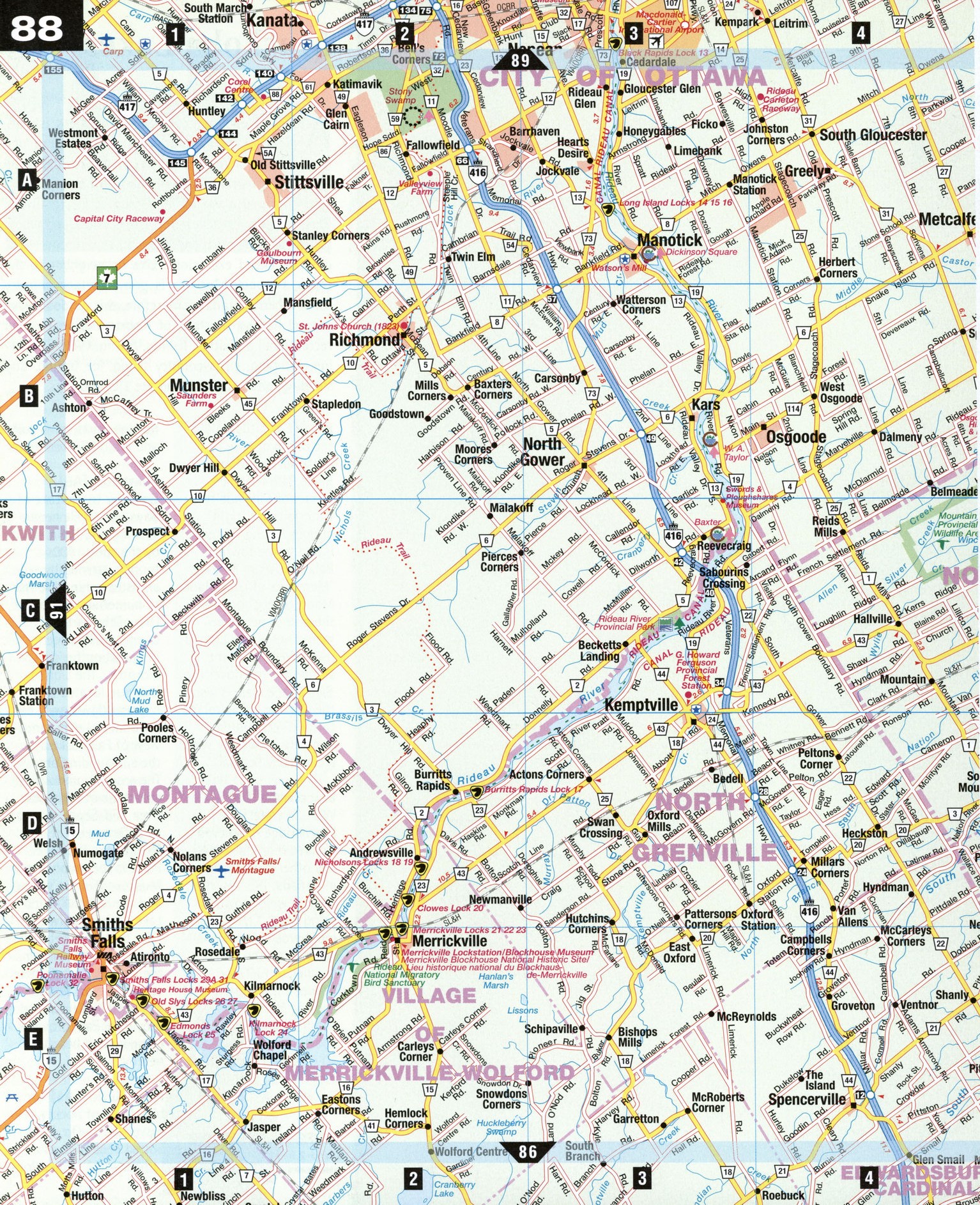
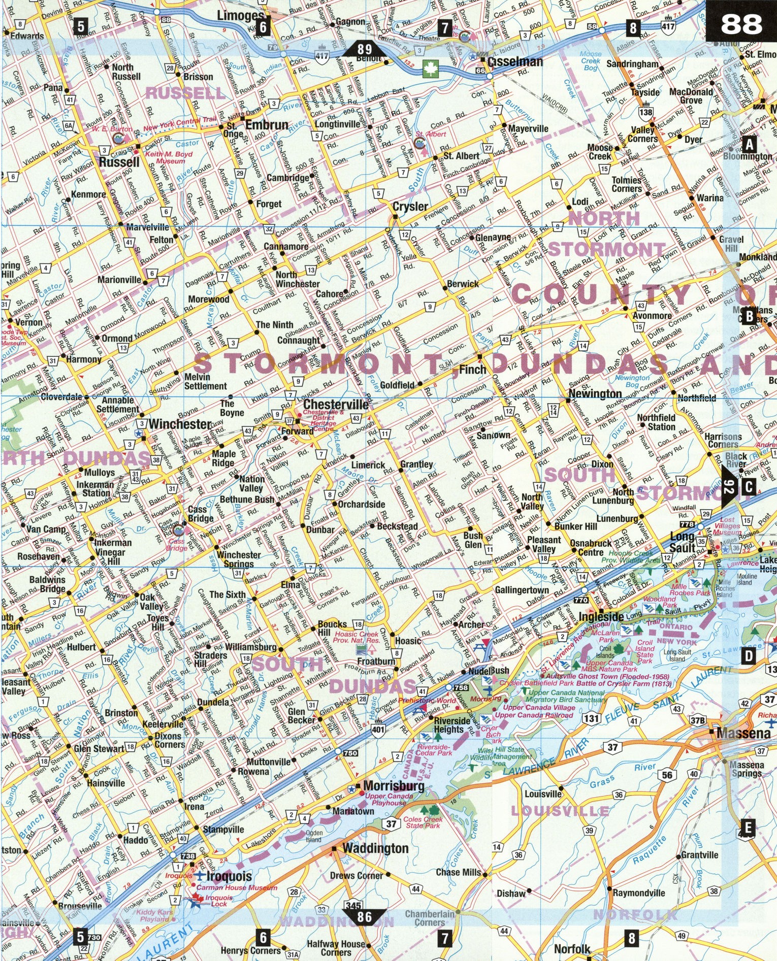
Large scale road map of Rideau Valle, province Ontario Canada
Road map of Rideau Valley. Detailed map of the highway and local roads of Rideau Valley with cities and towns.
Rideau Valley
Settlement in the Rideau Valley area began in the 1800s, with many communities forming around water-powered sawmills and gristmills. Fragments of the valley's history can be found along the route of the 202-km-long Rideau Canal, built by Col. John By and his Royal Engineers in 1826. Skilled stonemasons who worked on the canal also left their mark on the many fine stone buildings found throughout the region. Upper Canada Village, along the St. Lawrence River, offers an authentic taste of 19th-century life in the area. This lush region of the St. Lawrence River valley is also known for its apple farming, and is the home of the Mcintosh apple.
Iroquois [E6] Situated on the St. Lawrence, the Iroquois Locks are famous as one of the best places to view majestic lake-bound ships ("lakers") and ocean vessels ("salties") from all over the world as they pass through the seaway. In town is the Carman House Museum, a heritage home dating from 1815, which depicts family life from that era.
Kemptville [C3] Named after Sir James Kempt, the governor-general of Upper and Lower Canada in the 1820s, Kemptville is the agricultural and natural resource center for Eastern Ontario. The Kemptville College of Agricultural Technology was established here in 1917, and the G. Howard Ferguson Provincial Forest Station is one of the province's largest tree nurseries, with annual production at over 7 million trees.
Manotick [A3] Watson's Mill, located in the Dickinson Square Conservation Area, is considered one of the finest examples of gristmill architecture in the province. The three-story limestone building has been restored to its 1860 operating condition-arid still grinds wheat. The area also includes Dickinson House (1868), which housed Sir John A. Macdonald's 1882 campaign headquarters.
Merrickville [E2]
Merrickville is one of the oldest settlements along the canal corridor, and its largest blockhouse houses the Merrickville Blockhouse Museum. The unique lock station consists of three individual locks separated by turning basins. Nearby is the Rideau National Migratory Bird Sanctuary.
Smiths Falls [E1]
Smiths Falls is the halfway point on the Rideau Canal between Ottawa and Kingston. With both hand-operated and electric lock stations, this is the best place along the entire canal to see how the locks work. There are many heritage brick and limestone buildings, and a boating festival in July. Smiths Falls offers a unique passport to visit its four main attractions:
Heritage House Museum, Hershey Chocolate Factory, Rideau Canal Museum, and Smiths Falls Railway Museum. Ш Heritage House Museum is a restored heritage building with seven period rooms furnished to show the lifestyle of an upper middle-class family living in Smiths Falls around 1875. The original owner built two mills, a gristmill and woolen mill, powered by the nearby rapids. SHershey Canada Inc. opened its Smiths Falls factory-the first outside its native Pennsylvania and the first to include a visitors gallery—in 1963. It produces approximately 36 million kilograms of chocolate confectionary products per year. SRideau Canal Museum houses high-tech displays and artifacts about the history and construction of the canal in a former 19th-century mill. OSmiths Falls Railway Museum features exhibits in a former Canadian Northern Railway Station built in 1914. A 1950s diesel locomotive and a 1912 steam locomotive are also displayed, along with rare railway buildings. Track inspection cars called Wickhams give rides along the tracks around the museum grounds.
SPECIAL INTEREST
Upper Canada Village
When the St. Lawrence Seaway was built in the late 1950s, eight villages disappeared or were relocated to higher ground. Morrisburg was one such community, and the relocation of old buildings prompted the beginning of Upper Canada Village. Occupying 27 hectares of Crysler's Farm Battlefield Memorial Park, Upper Canada Village is a faithful re-creation of an Ontario United Empire Loyalists community. Homes, churches, mills, a tavern, general store, bakery, cheese factory, and broom maker are all peopled by costumed interpreters. The village operates much as it did in the late 1800s, with home deliveries from the bakery, the iceman making his rounds, and the ring of the blacksmith's hammer in the air. (Upper Canada Village is so authentically reproduced, it is often used as a movie set.) The Old Willard Hotel's dining room serves period meals, while the general store sells village-made crafts and products. Rides are available on horse-drawn wagons and a boat. A one-hour cruise on the St. Lawrence is available to explore the "Lost Villages."