Road map Prince George surrounding area (BC, Canada)
Detailed map of Prince George city area (British Columbia, Canada)
Road map of Prince George city area and Kitimat Ranges. Detailed map of the highway and roads of Prince George city area and Kitimat Ranges (BC Canada).
Large scale map of Prince George city area (British Columbia, Canada)
Road map of Prince George city area and Kitimat Ranges. Detailed map of the highway and roads of Prince George city area and Kitimat Ranges (BC Canada).
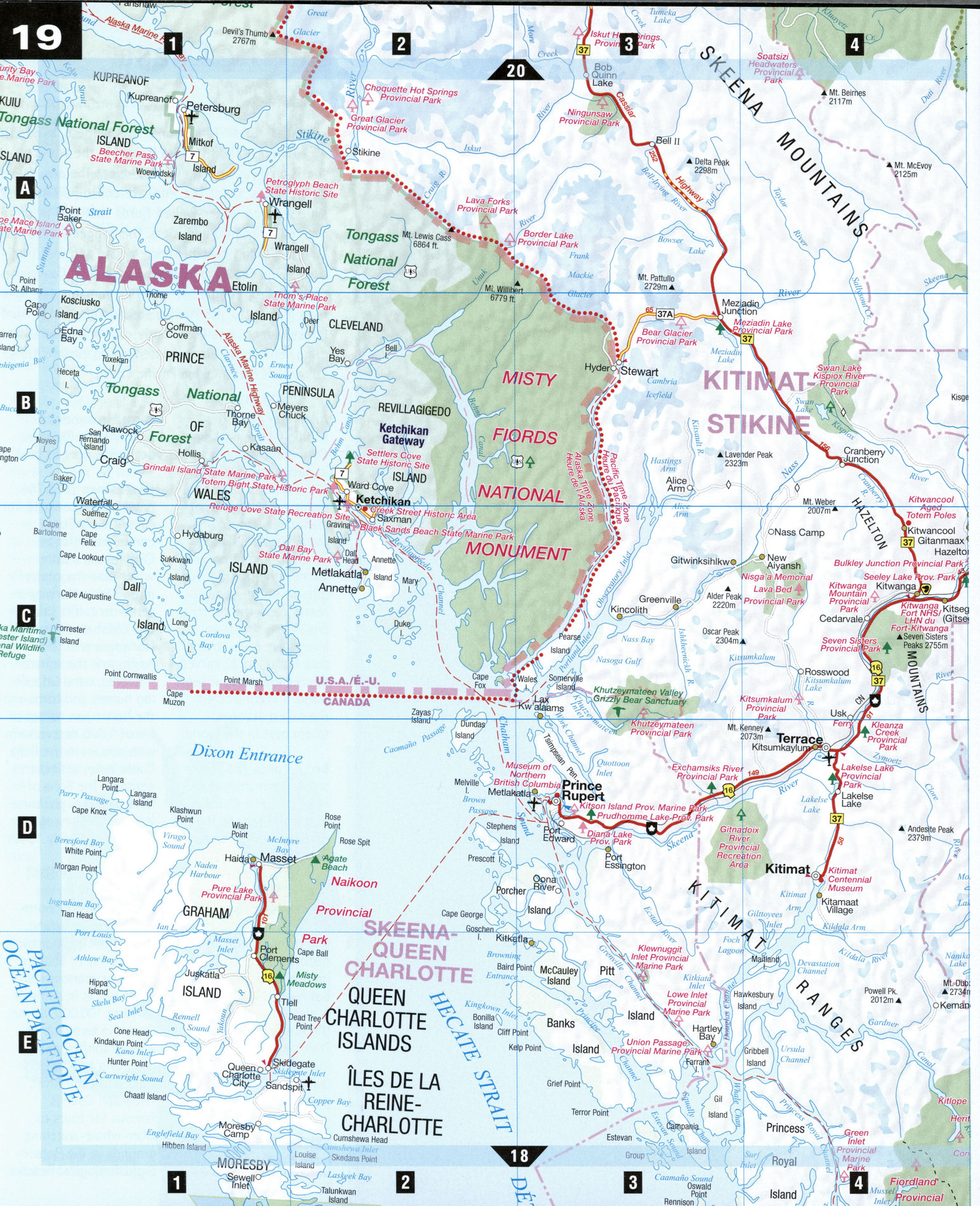
Kitimat Ranges
From Prince George the Yellowhead Highway (Highway 16) traces the Canadian National Railway route (once the Grand Trunk Pacific Railway route) before reaching the Kitimat Ranges and Prince Rupert, gateway by ferry to Alaska and the Queen Charlotte Islands. Along the way are towns that owe their beginnings to Native fishing villages, the fur trade, the Gold Rush, the railway, salmon canneries, sawmills, and mines, as well as bird sanctuaries, unique landscapes carved by molten lava, and the world's most spectacular collection of totem poles.
Fort St. James [D7] In 1806, Simon Fraser and his crew built a trading post on the shores of Stuart Lake. Today fur-trade days flourish and Fraser's spirit lives on at Fort St. James National Historic Site, which boasts the largest collection of fur-trade structures still standing on their original location. Staff in period dress re-create life as it was in the 1890s.
The Hazeltons [C4-C5]
This cluster of towns-comprising Hazelton, South Hazelton, and New Hazelton-have been home to the Gitxsan First Nation for thousands of years. Explore their rich past on the Hands of History Driving Tour between The Hazeltons and Kitwanga. The tour covers 19 marked historic sites and dozens of elaborately carved totem poles along the way, many depicted in Emily Carr's paintings. The 'Ksan Historical Village and Museum is a re-created traditional Gitxsan village, showcasing their unique art and culture. Tour tribal longhouses, learn the legends behind the totem poles created at the Gitanmaax School of Northwest Coast Indian Art, and sample traditional aboriginal cuisine.
Kitimat [D4] Located at the head of a 90-km-long navigable fjord, Kitimat was built in the early 1950s by Alcan Smelters and Chemicals Ltd. The natural deep-sea harbor, flat land for development, and accessibility of hydroelectrici-ty made Kitimat a perfect choice for the new plant. Take advantage of the free tour of the massive smelter, one of the world's largest. The Kitimat River is famous for salmon, trout, and steelhead fishing; the Douglas Channel for salmon and halibut.
Nisga'a Memorial Lava Bed Provincial Park [C4] Some 250 years ago, molten lava spilled down the Tseax Valley, killing 2,000 Nisga'a people. Today, apart from tenacious lichens and mosses, little vegetation pokes through the dramatic moonscape terrain here. Explore the park's rich native culture, and discover unique features of a volcanic landscape, including lava tubes and spatter cones.
Bushplanes in Prince Rupert
Prince Rupert [D3]
Towering mountains serve as a backdrop to this bustling transportation hub for ferry, air, and rail travel. Prince Rupert harbor is said to be the world's third largest natural ice-free deep-sea harbor, and the area is rich in archaeological sites. Archaeology harbor tours to the village of Metlakatla leave from the Museum of Northern British Columbia; the dramatic longhouse-style museum building is well worth a visit. In Port Edward, 20 km south of Prince Rupert, is the North Pacific Cannery Village Museum, a national historic and cultural site that comes to life in summer with live performances and costumed guides. Built in 1889, it is the oldest surviving salmon cannery in the province.
Smithers [C5] Its location at the base of Hudson Bay Mountain, Bavarian-style storefronts, murals, and redbrick sidewalks make Smithers a shutterbug's delight. The surrounding wilderness is a mecca for outdoor enthusiasts, especially hunters and fishers. Driftwood Canyon Provincial Park has intriguing fossils, the Smithers Community Forest an interpretive nature trail, and Adams Igloo Wildlife Museum an extensive collection of mounted fauna.
SPECIAL INTEREST
Queen Charlotte Islands
Shrouded in mist and rain, this 250 km archipelago of more than 150 islands has been the Haida Gwaii (homeland) to the Haida for thousands of years. Reached by ferry from Prince Rupert, Graham Island is the largest, most populous, and easy to get around by car. In Naikoon (Haida for "long nose") Provincial Park, visitors can comb the pristine beaches for driftwood and agates, or catch a glimpse of Sitka deer, bald eagles, and seals. Whales often appear along the shores and inlets. The rich arts and culture of the Haida is still alive in the old villages of Massett, Port Clemens, and the Haida Gwaii Museum at Skidegate, which houses the world's largest collection of carvings in argi I lite, a soft black slate rock found only in the Charlottes.
Moresby Island is mainly taken up by Gwaii Haanas National Park Reserve, accessible only by air or sea. The village of Ninstints on Anthony Island, at the southern tip of the Charlottes, has been designated a UNESCO World Heritage Site. Remains of houses and carved mortuary and memorial poles illustrate the Haida people's art and way of life. Tours are available from Queen Charlotte City.