Road map Pacific Coast BC surrounding area (British Columbia, Canada)
Road map of Pacific Coast province British Columbia
Map of Pacific Coast BC. Detailed map of the highway and local roads of Pacific Coast BC with cities and towns.
Large scale map of Pacific Coast province British Columbia
Map of Pacific Coast BC. Detailed map of the highway and local roads of Pacific Coast BC with cities and towns.
Pacific Coast BC
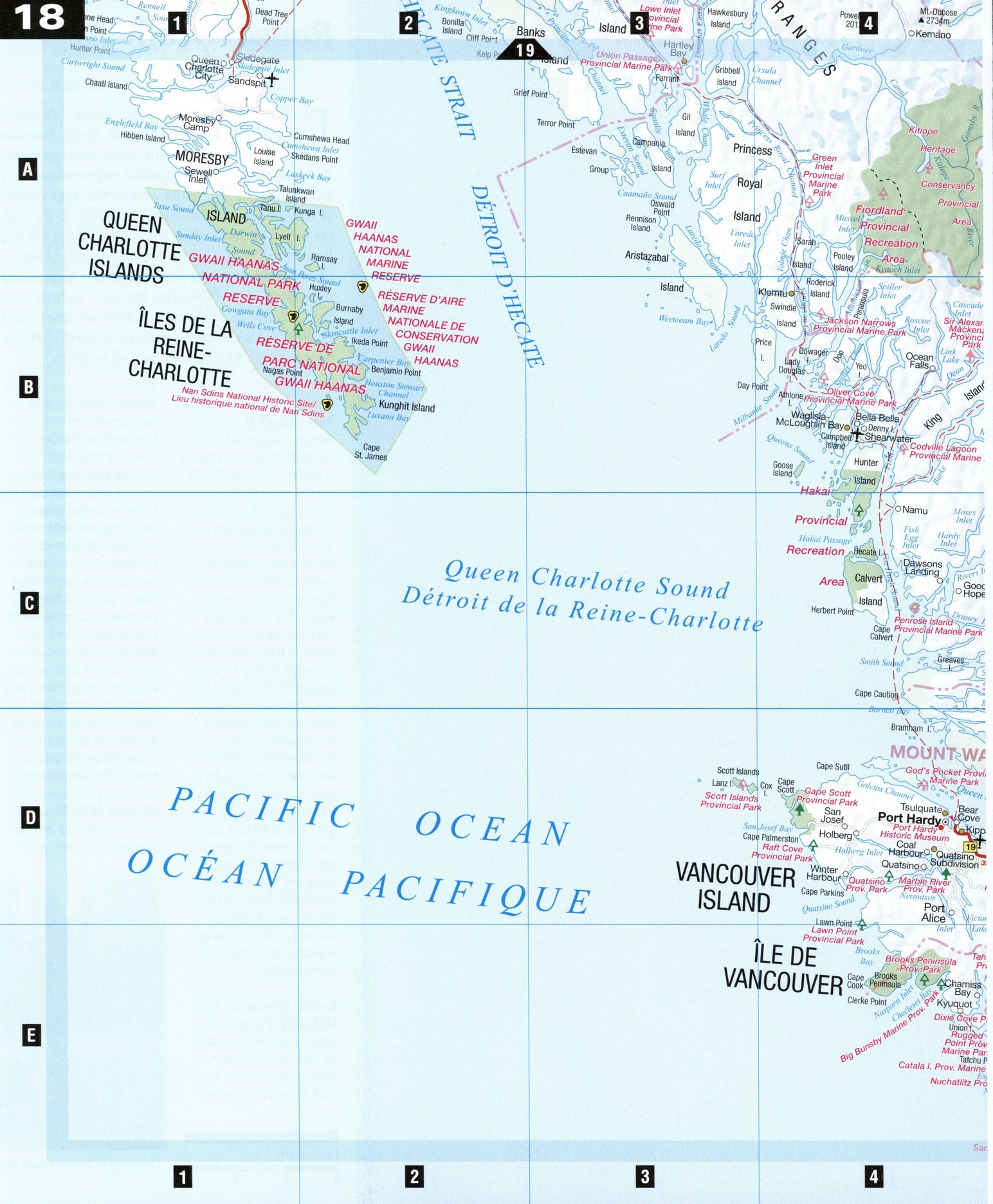
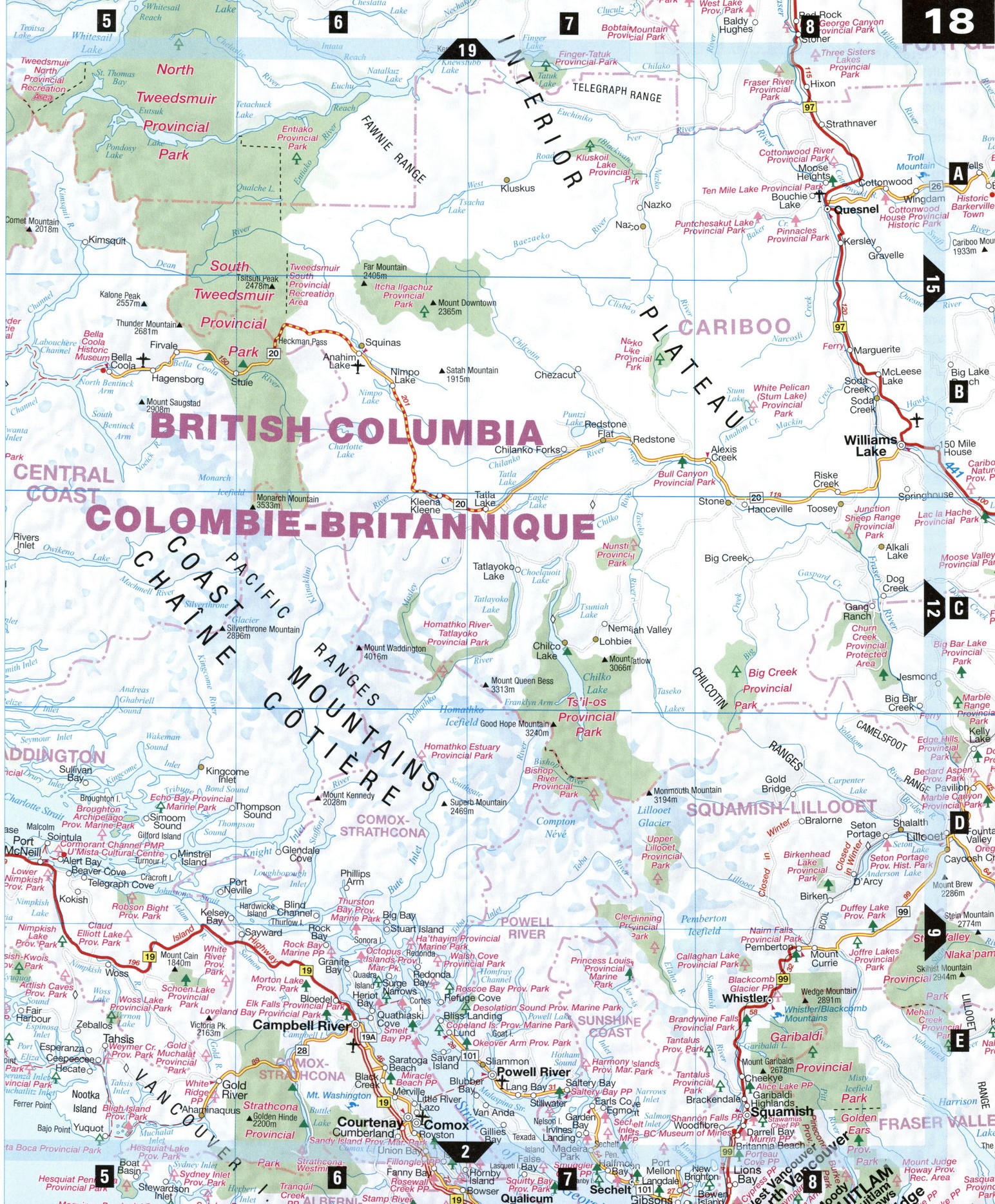
As the Coast Mountains-the highest in North i America and the third largest in the world after the Himalayas and the Andes-meet the sea, rivers and glaciers sculpt the intricate coastline into long slivers-steep, sheer-walled fjords that end in more than 6,000 islands and islets. This ruggedly beautiful land is difficult to experience by car, and was traditionally navigated by canoe, kayak, and floatplane. Highway 20, completed in 1953, remains the lone road leading to the Pacific. Today cruise ships from Prince Rupert and Port Hardy on Vancouver Island bring vehicles and their passengers to explore British Columbia's breathtaking Pacific Coast.
Alert Bay [D5] This fishing village on tiny Cormorant Island is rich in native cultures. The U'mista Cultural Centre displays a collection of elaborately carved masks, baskets, and other artifacts from pot-latches, the traditional gift-giving ceremonial feasts. Near the center's Big House stands an impressive 53 m totem pole featuring 22 carved figures topped by a sun mask. It is considered the tallest standing totem pole in the world.
Bella Coola [B5] This small community at the head of Burke Channel has been home to the Nuxalk First Nation for thousands of years; Norwegians later settled here in 1894. The Bella Coola Valley Museum exhibits local artifacts and recounts the area's history. Hiking and biking trails are plentiful but rugged. Bella Coola is also the terminus of the Alexander Mackenzie Trail, which stretches inland 420 km to Quesnel. Mackenzie's graffiti can be seen carved in a rock in nearby Dean Channel, accessible only by boat.
Hagensborg [B5] The name of this town 18 km east of Bella Coola comes from Hagen Christensen's store, which was the center of an 1890s Norwegian settlement. It is said the B.C. coast reminded the Norwegians of their home, and the square-timbered, hand-adzed log homes and barns and the Norwegian names of about 1,000 descendants who remain in the Bella Coola Valley reflect this heritage. The Sons of Norway Heritage House is a typical Norwegian home of the early 1900s.
Telegraph Cove [D5]
Tucked away on the eastern coast of northern Vancouver Island, this charming boardwalk community of about a dozen permanent residents swells in summer to some 100,000 visitors. Once the terminus of a telegraph/telephone line hung tree to tree from Campbell River, Telegraph Cove is famous for tours to killer-whale-watching grounds in the Robson Bight Ecological Reserve.
In town you can listen to the squeals and clicks of whales piped into Killer Whale Cafe and Old Saltery Pub from the ORCA-FM station.
Tweedsmuir Provincial Park [B5-B6] This 9,600 km2 park is the largest in B.C. While the northern half of the park has no road access, Hwy 20 cuts through the southern half, where one can glimpse the peaks of the Rainbow Range-an enormous dome of lava that has been eroded to expose vivid colors-and the Hunlen Valley, a popular canoe circuit consisting of a chain of seven lakes connected by Hunlen Creek. At Turner Lake, at the end of the chain, the waters pour over Hunlen Falls 393 m to land in the Atnarko River. There are trails and campgrounds along this canoe circuit. Heckman Pass, at an elevation of some 1,524 m, is the highest point on the infamous Bella Coola Hill, a 10 km stretch of switchbacks, steep dropoffs, and 18% grades that puts fear into any driver about to ascend it from the west or descend it from the east.
ATTRACTIONS
ALERT BAY
Alert Bay Library and Museum Alert Bay Art Gallery Gator Gardens Ecological Park U'mista Cultural Centre
BELLA COOLA
Bella Coola Valley Museum Sir Alexander Mackenzie
Provincial Park Clayton Creek Trail and Recreational Area Thorsen Creek Petroglyphs
HAGENSBORG
Sons of Norway Heritage House
Saloompt Interpretive Trail Lost Lake Trail Odegaard Falls
TELEGRAPH COVE
Killer Whale Cafe Old Saltery Pub Campbell River Pulp Mill Tour
Killer-whale-watching tours