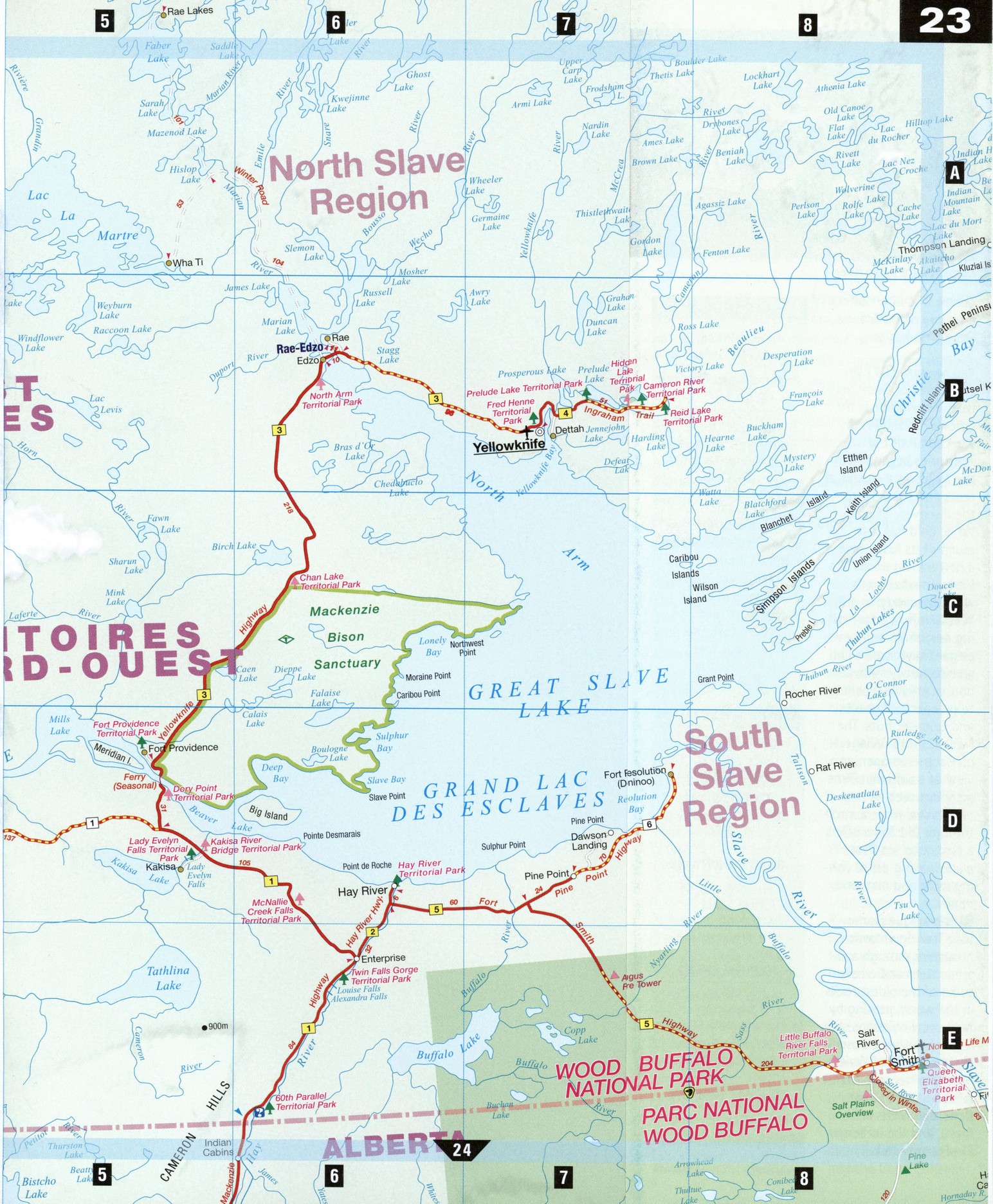
Northwest Territories map with roads, cities, towns
Road map of Northwest Territories, Canada
Map of Northwest Territories, Canada. Detailed map of the highway and local roads of Northwest Territories with cities and towns. Free large scale map of Northwest Territories, Canada.


Detailed map of Northwest Territories with cities and towns
Map of Northwest Territories, Canada. Detailed map of the highway and local roads of Northwest Territories with cities and towns. Free large scale map of Northwest Territories, Canada.
Northwest Territories
The Slavey Dene First Nation call the area around Great Slave Lake and the Mackenzie River Deh Cho, or "Big River," and "big" is the only way to describe the Northwest Territories. After the establishment of Nunavut in 1999, the Territories shrank in size, yet this "Land of the Midnight Sun" (the sun shines for 20 hours a day in summer) still covers a staggering 1.17 million square kilometers of pristine arctic wilderness. Seasoned canoeists and river rafters will relish the challenge of Nahanni National Park Reserve, with its dramatic canyons and turbulent rivers. Prospectors are once again putting down stakes here, now the diamond capital of North America. Attractions and accommodations outside of Yellowknife can be decidedly spartan, but the locals are warm and welcoming. One Inuktitut word for "tourism" means "taking tea with a visitor," and having tea and bannock with a trapper, a carver, or a moose hair tufter may be the best way to experience Canada's North.
Fort Providence [D5]
Once a busy Roman Catholic Mission during the 1850s, Fort Providence is now known for its unique crafts, such as moose hair tufting and porcupine quill embroidery. The Snowshoe Inn arts and crafts shop is a must-see stop. You may also spot some wood bison-right in town.
Fort Simpson [C3]
Situated at the confluence of the Liard and Mackenzie rivers, this old fur-trading post is known as "The Garden of the Mackenzie," a title that has roots both in the farming done long ago by the Roman Catholic Mission to supply their hospital, school, and mission, and more recently in the federal government's experimental farm to develop suitable northern varieties of vegetables, crops, and flowers. Locals still pride themselves on their gardens. From town, visitors can charter floatplanes to fly into Nahanni National Park Reserve.
Hay River [D6] Like many northern communities, this busy town began as a Hudson's Bay Company outpost. Its location at the end of Great Slave Lake made Hay River an important transportation and communications hub. (Hay River's daily newspaper is called The Hub.) Unusual attractions include Diamond Jenness, a purple school whose color was selected by the students, and Perron's Funny Farm, one of the few livestock producers in the north, and the Hay River Dene Reserve, worth visiting to see its colorful church, fish-drying racks and the Dene Cultural Kayaks on the Slave River Centre. The latter offers a history of the Slavey Dene First Nation.
Yellowknife [B7] On the shores of Great Slave Lake, Yellowknife is the gateway to the Arctic. The capital of the Territories began life in the 1930s as a cluster of tents and shacks after the discovery of gold. While gold has lost much of its luster here, a new mining boom has hit town-diamonds were discovered in 1991. Yellowknife is a fascinating mix of old and new-elegant skyscrapers and architecturally innovative houses provide a contrast to prospectors' shacks and Quonset huts. The Ndilo Cultural Village offers an eye-opening view of traditional Dene activities such as tanning hides, while a stroll through Old Town offers a chance to see floatplanes taking off to fishing lakes and diamond mines.
The unique Frame Lake Trail downtown meanders through subarctic trees and crosses some of the oldest rocks in the world, passing by fancy new buildings such as the Legislative Assembly, the Prince of Wales Northern Heritage Centre (a repository of Inuit, Dene, and Metis artifacts), and the iceberglike Explorer Hotel.
CITY GUIDE
YELLOWKNIFE ATTRACTIONS
Prince of Wales Northern Heritage Centre Northern Arts and Cultural Centre Northwest Territories Legislative Assembly
Building Visitor Information Centre Explorer Hotel Bush Pilot's Monument Ndilo Cultural Village Old Town Tours Frame Lake Trail Ingraham Lake Trail Niven Lake Trail Prelude Lake Wildlife Trail Wildcat Cafe
AIRPORT INFORMATION
(867) 873-2840
RADIO STATIONS
CJCD 1240 AM CBC North Radio Two 95.3 FM
ROAD CONDITIONS
1-800-661-0751 (Hwy 1 and 7) 1-800-661-0752 (Hwy 8)
TOURISM OFFICE
Visitor Information Centre, #2, 4807 49th St. (867) 873-3131 or 1-877-881-4262
TOURISM WEB SITE
http :// city. yellowknife. nt. ca