Northern Yukon detailed road map with cities and towns
Road map of Northern Yukon (Canada)
Map of Northern Yukon. Detailed map of the highway and local roads of Northern Yukon with cities and towns.
Large scale road map of Northern Yukon (Canada)
Map of Northern Yukon. Detailed map of the highway and local roads of Northern Yukon with cities and towns.
Northern Yukon
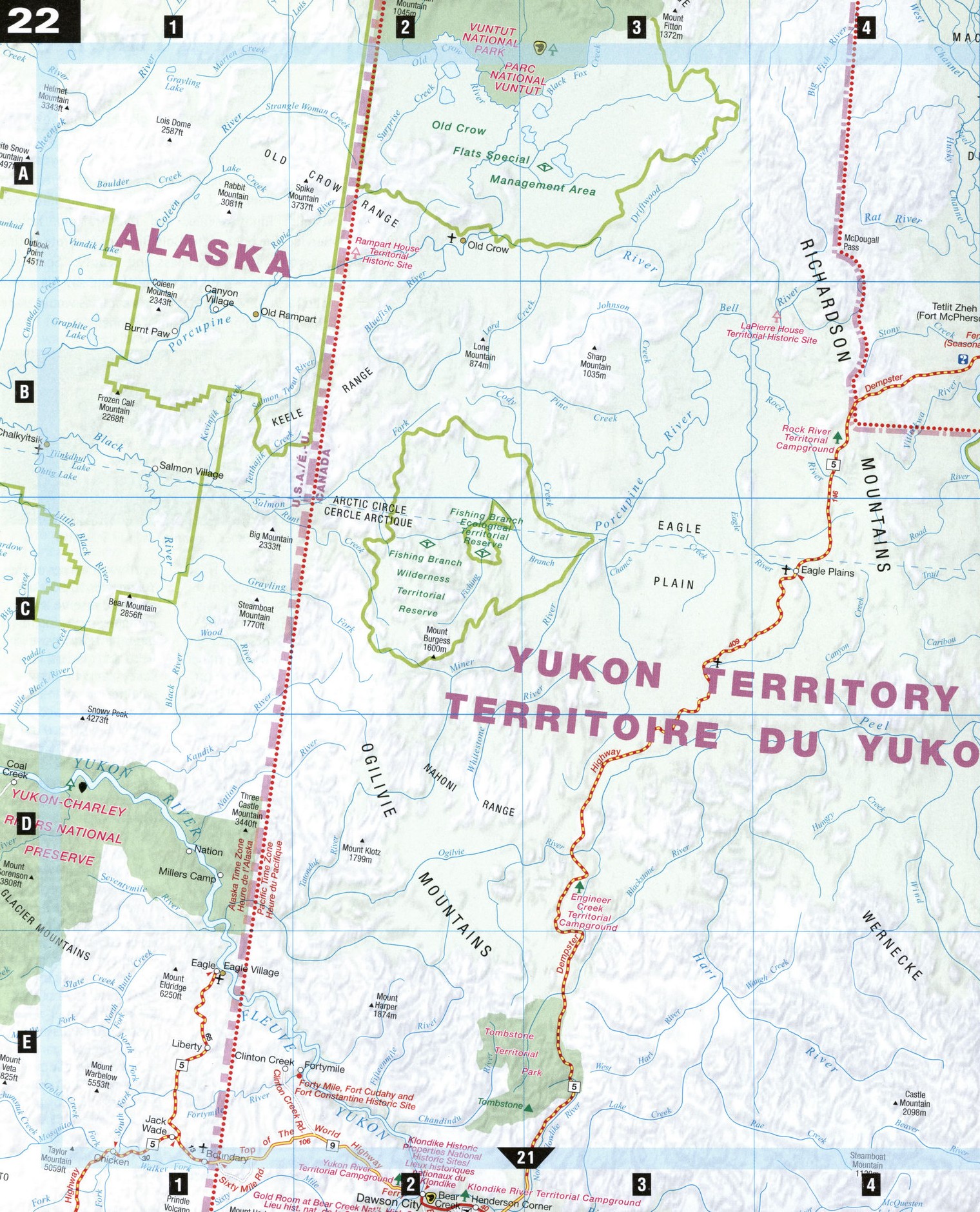
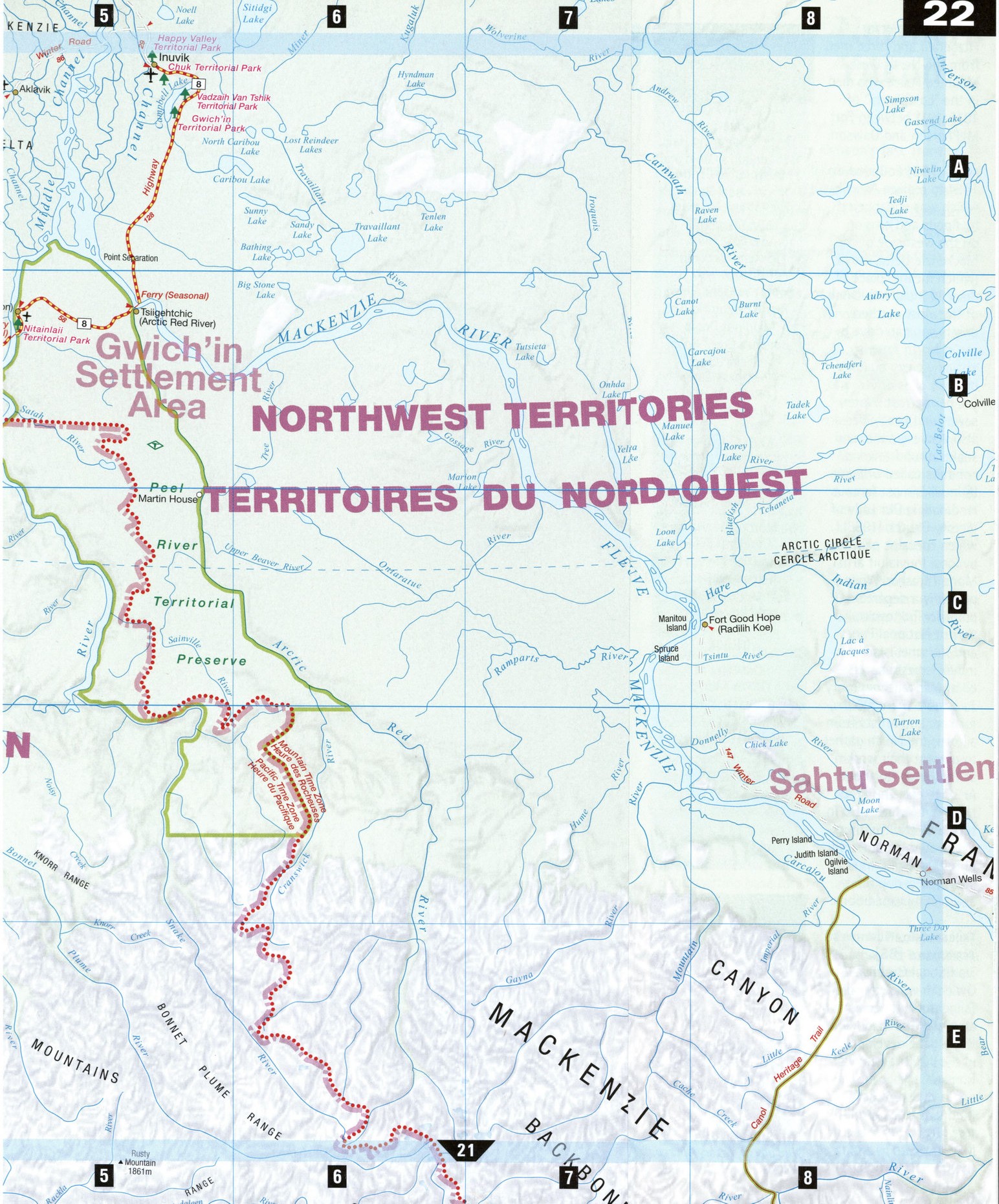
The northern Yukon is Canada's last frontier. The Dempster Highway (Highway 5 in the Yukon, Highway 8 in the Northwest Territories), a 743-km-long hard-packed gravel road between Dawson City and Inuvik, traces the route used by Royal North West Mounted Police dog team patrols in the early 1900s, and offers unforgettable glimpses of mountain ranges, alpine tundras, and rich marshes in a land where the sun never sets. Whether you wish to relive Gold Rush days or dip your toe in the Arctic Ocean, the Dempster is your path through this endless white wilderness, exotic wildlife, and Native traditions.
Dawson City [E2]
When word of the 1896 Bonanza Creek gold strike sparked the Klondike Gold Rush, Dawson, a tiny settlement at the confluence of the Yukon and Klondike rivers, sprang up almost overnight, and soon became a thriving city of some 30,000 gold-seekers. Today some of Dawson's original saloons and hotels survive and have been restored, including the 1899 Palace Grand Theatre, an elaborate showplace that stages the Gaslight Follies in summer. Guided walking tours of Dawson's historic district are available, and the Visitor Reception Centre is a good starting base for information on the city's brief but rich historic past. Take a sight-seeing lunch or dinner cruise up the Yukon River on the paddle wheeler Yukon Lou, or visit the restored (c.1898) log cabin of Robert W. Service, the bard of the Klondike. It was here that Service wrote many of his poems plus the melodramatic novel The Trail of'98. Don't miss the Commissioner's Ball and trek to the Dome to see the Midnight Sun in June, and Discovery Days in August.
Eagle Plains [C4]
The midpoint of the Dempster Highway, Eagle Plains offers the only chance to fill your gas tank before Fort McPherson. In the midst of arctic wilderness, the oasis of the Eagle Plains Hotel offers modern rooms, a restaurant, lounge, gift shop, and full camper services. Thirty-six kilometers north of Eagle Plains Hotel, at Kilometer 403, is the Arctic Circle, and beyond it lies the Land of the Midnight Sun.
Fort McPherson, Northwest Territories [B5] Originally named the Peel River Post, this Gwich'in Dene community was established in 1840 as a Hudson's Bay Company fur-trading post. The cemetery beside St. Matthew's Church-the base of the Anglican Church's operations in the western Arctic-contains the graves of Inspector Fitzgerald and three men from the North West Mounted Police who died in the "Lost Patrol" of 1910-1911 between Fort McPherson and Dawson.
Inuvik [A5] Founded in 1954 to replace Aklavik, which was endangered by floods and erosion on the west side of the Mackenzie Delta, Inuvik (which means "place of man" in Inuktitut) is one of the most northerly points you can drive by car in North America. Virtually every building is built on piles driven into the permafrost. Water, sewer, and heat pipes are also above ground, and snake around town in conduits called utilidors. BBInuvik's most famous landmark is Our Lady of Victory Church (1958), which contains paintings by local Inuvialuit artist Mona Thrasher. While primarily a departure point for Tuktoyaktuk, Vuntut National Park, and Herschel Island, Inuvik is best appreciated at festival time; every July, more than 100 performers and artists from all over the North gather to present their work at The Great Northern Arts Festival. The Arctic Northern Games, held in several Arctic communities in July, include traditional Dene and Inuit sports, sled-dog rides, and fishing expeditions.
Tsiigehtchic, Northwest Territories [B5]
Traditional Gwichya Gwich'in ways prevail in Tsiigehtchic (once known as Arctic Red River), a tiny village developed in the 1860s around a Roman Catholic mission and a Hudson's Bay Company post. A toll-free ferry bridges the Mackenzie as part of the Dempster Highway.
ATTRACTIONS
Dawson city
Dawson City Museum Palace Grand Theatre
Diamond Tooth Gertie's Gambling Hall Jack London's Cabin and Interpretive Centre
Dawson City Firefighters Museum MV Yukon Lou riverboat tours SS Keno National Historic Site Robert Service's Cabin Pierre Berton House
Midnight Dome Bonanza Creek Road Ancient Voices Wilderness Camp Ridge Road Heritage Trail eagle plains
Eagle Plains Hotel
fort Mcpherson
St. Matthew's Anglican Church (1860)
Peel River Mackenzie Delta Fort McPherson Tent and Canvas tours
Inuvik
Our Lady of Victory Church
Ingamo Hall Community Centre Arctic Nature Tours