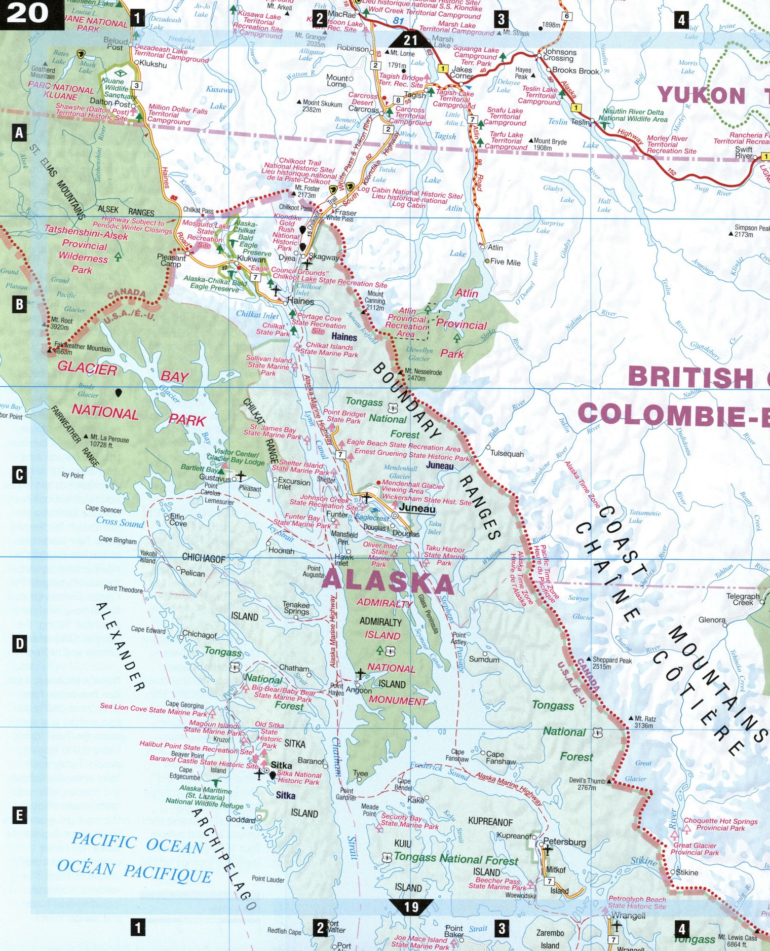
Road map Northern British Columbia area (BC, Canada)
Road map of Northern BC (British Columbia, Canada)
Map of Northern British Columbia. Detailed map of the highway and local roads of Northern British Columbia with cities and towns.
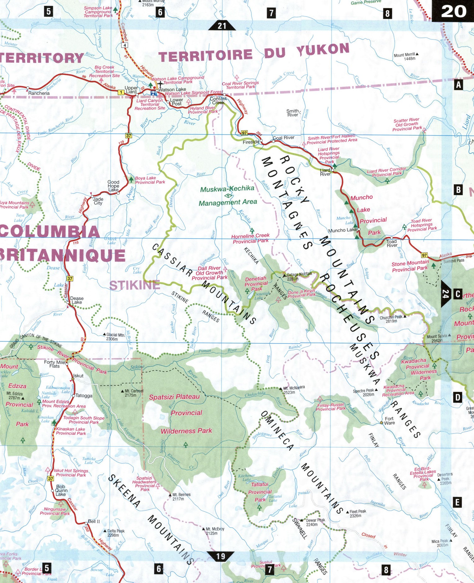
Large scale map of Northern BC (British Columbia, Canada)
Map of Northern British Columbia. Detailed map of the highway and local roads of Northern British Columbia with cities and towns.
Northern British Columbia
This immense wilderness straddling the Continental Divide between the Coast Mountains and the Northern Rockies has some of Canada's most bold, rugged, and unique topography: lofty, four-million-year-old volcanic mountain peaks, tiny deserts, mineral-tinted lakes, and rivers that surge through 300-m-deep grand canyons. Road travelers must content themselves with fleeting glimpses of this majesty; for a bird's-eye view, enlist the services of bush pilots, guides, and outfitters and fly, hike, or raft.
Atlin [ВЗ] Overlooking the glacial meltwaters of Atlin Lake, the province's largest natural body of water, Atlin City was founded in 1898 when prospectors bound for the Klondike discovered gold in nearby Pine Creek. Atlin acquired a worldwide reputation in the 1920s as a destination for elite travelers who arrived aboard the MV Tarahane (which now rests on the lake shore). Gold mining still attract visitors here.
Carcross, Yukon [A2]
A sleepy lakeside community of century-old houses surrounded by mountains, Carcross was home base for George Carmack, Skookum Jim, and Tagish Charlie, whose find at Bonanza Creek in 1896 started the Klondike Gold Rush. The last spike in the White Pass Railroad-joining Skagway, Alaska, and Whitehorse-was driven in Carcross in 1900. Just north of town are Frontierland (formerly the Museum of Yukon Natural History), a huge heritage park where you can see some of Yukon's elusive wildlife, and Carcross Desert, which at 260 hectares is said to be the world's smallest.
Chilkoot Pass National Historic Site [A2]
Hikers from around the world come to hike the Chilkoot Trail, a 53 km trail following in the footsteps of prospectors on their way to Dawson, the City of Gold, during the Klondike Gold Rush of 1896-98. The trail begins on Dyea Road 13 km from Skagway, Alaska, before climbing the 1,066 m Chilkoot Pass, and ending at Lake Bennett. The reward for hiking this still arduous trail is no longer gold but spectacular scenery and glimpses of relics left behind by frustrated prospectors as they sought to lighten their load. Check with the Trail Centre in Skagway for information, permits, and reservations.
Dease Lake [C5] This village flourished as a center for the 1872-80 Cassiar Gold Rush. Today, it serves travelers seeking gas, food, and accommodation on the Cassiar Highway, and hunters, guides, and outfitters bound for Mount Edziza and Spatsizi Plateau wilderness parks. Recently, Dease Lake has dubbed itself the Jade Capital of the World for the abundance of jade in the area.
Liard River Hot Springs Provincial Park [B8] An oasis for weary travelers on the Alaska Highway, Liard River Hot Springs invites visitors to soak in its relaxing spring-fed waters, which range in temperature from 42°C to 52°C. In the Hanging Gardens, the warm water and higher air temperature fosters the lush growth of about 250 plants, including 14 species of orchids.
Telegraph Creek [D4]
The historic community of Telegraph Creek, home of the Tahltan First Nation, site of an intercontinental telegraph project abandoned in 1866, and former head of steamship navigation on the Stikine, is now a jumping-off point for hikers and river rafters. Its main street has scarcely changed from Gold Rush days. The 113-km-long road between Telegraph Creek and Dease Lake is a narrow, roller-coaster, switchbacking gravel road built over lava beds and cut from canyon walls and affords breathtaking panoramic views of the Stikine and Tahltan canyons.
Watson Lake, Yukon [A6] Watson Lake is famous for its unusual Signpost Forest, a collection of over 42,000 road signs and messages from around the world displayed on posts at the west end of town. The practice began in 1942 when a homesick U.S. Army soldier erected a carved sign of Danville, Illinois, to remind him of his home town. Over the years, tourists have continued the tradition.
ATLIN
Atlin Museum Atlin Centre for the Arts Atlin Pioneer Cemetery
Atlin Provincial Park MV Tarahane Restaurant Spruce Creek (public gold panning)
CARCROSS
White Pass and Yukon Route Railroad Station Frontierland Carcross Desert
JADE CITY
Jade City Store Bear Country Rock, Gem, and Gifts
TELEGRAPH CREEK
Hudson's Bay Company Trading Post Stikine Riversong Inn and Cafe Tahltan River Bridge
WATSON LAKE
Signpost Forest Alaska Highway Interpretive Centre Tlingit Heritage Centre Northern Lights Space and Science Centre Klondike Gold Dredge Tours Lucky Lake