Road map Lower Fraser Plateau surrounding area (BC, Canada)
Road map of Lower Fraser Plateau (BC Canada)
Map of Lower Fraser Plateau (British Columbia, Canada). Detailed map of the highway and local roads of Lower Fraser Plateau with cities and towns. Large scale road map Williams Lake city area.
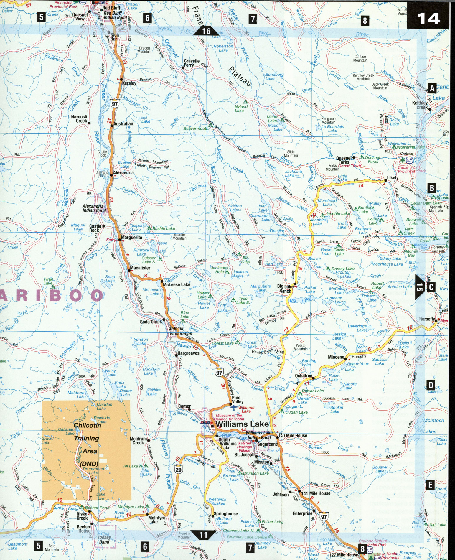
Free map of Lower Fraser Plateau (BC Canada)
Map of Lower Fraser Plateau (British Columbia, Canada). Detailed map of the highway and local roads of Lower Fraser Plateau with cities and towns. Large scale road map Williams Lake city area.
Lower Fraser Plateau
The plateau region west of Williams Lake and north of the Upper Chilcotin Ranges is the land of the proud Interior Salish First Nations, among them the Tsilhqot'in, Secwepemc, and Dakelh tribes-hardy, independent people with a strong sense of community bred from years of isolation and hardship. The Interior Plateau is an open rolling land offish-stocked lakes and jack pine forests, of vast, isolated cattle-and-horse ranches, of remote fly-in fishing resorts and tiny "blink and you'll miss it" towns, where the general store is still the focal point of the community.
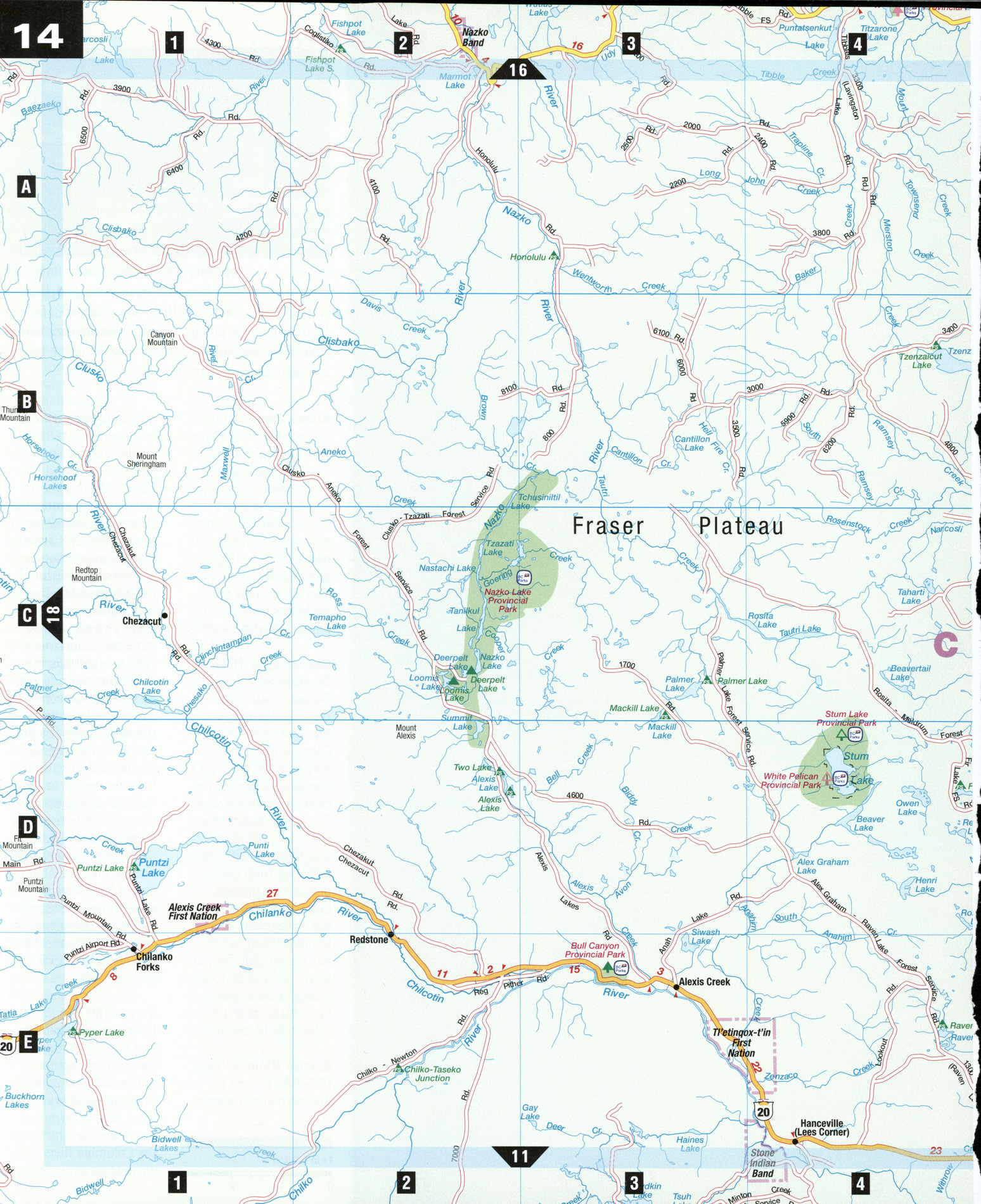
Bull Canyon Provincial Park [E3] Located in a beautiful canyon, this scenic 369-hectare park is noted for its caves, sheer rock walls, and the ice-blue, fast-flowing Chilcotin River. It was here that the Secwepemc and Tsilhqot'in peoples fought an historic battle. There is a short walking trail beside the river, and the surrounding area supports superb fishing and bird-watching.
Nazko Lake Provincial Park [C2] Originally a wilderness canoe route, this 12,419-hectare area became a provincial park to protect the region's wetlands. Situated some 100 km northwest of Williams Lake, Nazko Lake Provincial Park provides fishing, camping, and wildlife viewing. The Nazko Lake Canoe Chain offers two- to four-day canoe trips. The 20 km route spans six lakes, with easy portages. Chat with the locals to find the best fishing holes and ask for directions to an ancient volcano site favored by rock hounds.
Puntzi Lake [D1]
Accessed from Chilanko Forks, some 60 km west of Alexis Creek, this lake is filled with trout and kokanee in summer, and offers good ice-fishing for whitefish in winter. Endangered white pelicans rest and feed here in spring and summer, and trumpeter swans in autumn. Puntzi was once the site of a U.S. Air Force base, remnants of which include a radar station built atop Puntzi Mountain in the 1950s. Visitors can take the airfield road to the mountain summit for a 360° view of the Chilcotins.
Riske Creek [E5] The natural grasslands surrounding this small community west of Williams Lake attracted the Chilcotin's first ranchers. The town was named for Mr. Riske, a Polish farmer who in the 1860s built a flour mill and sawmill, and sold his produce to Barker-viMe at the time of the Cariboo Gold Rush. South of Riske Creek a gravel road switchbacks down into Farwell Canyon, a spectacular setting of hoodoos, sagebrush, sand dunes, and river.
Soda Creek [C6]
Located at the head of the upper Fraser River Canyon, Soda Creek gets its name from the carbonate of lime in its creek bed, which causes the water to bubble like soda water. During the Cariboo Gold Rush, stern-wheelers were brought here by road and then reassembled to carry miners north along navigable waters to Quesnel at the entrance to the goldfields. The Xats'ull First Nation village shares its 2,000-year-old history with tours of the Xats'ull Heritage Village. View ancient petroglyphs, demonstrations of tool and basket making, and traditional food preparation. You can also take part in a traditional sweat lodge.
Williams Lake [D7]
Depending on who you talk to, Williams Lake was named either for Will'yum, a Shuswap First Nation chief who kept peace between natives and local settlers, or William Pinchbeck, a wealthy rancher. This sprawling town situated on the lake of the same name is B.C.'s main livestock center. The town's claim to fame is the Williams Lake Stampede, the province's largest rodeo, a four-day celebration held every July. Traditional cowboy skills are displayed in events including calf roping, steer wrestling, and bronco riding. Homegrown events include pony express race, wild-cow milking, team cattle penning, pony chariot race, and the top dog competition. British Columbia's only museum devoted to rodeo and ranching, The Museum of the Cariboo-Chilcotin, gives visitors a history of the Stampede.
ATTRACTIONS
ALEXIS CREEK
The Chilcotin Hotel The Old School House Alexis Lake Resort
PUNTZI LAKE
Puntzi Mountain Kokanee Bay Resort
RISKE CREEK
Cariboo Chilcotin Jetboat Adventures
SODA CREEK
Xats'ull First Nation Heritage Village
WILLIAMS LAKE
Scout Island Nature Centre Museum of the Cariboo-Chilcotin Williams Lake River Valley Trail Williams Lake Stampede