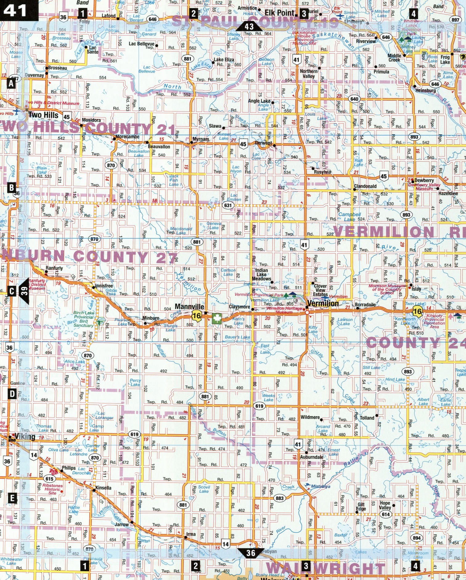
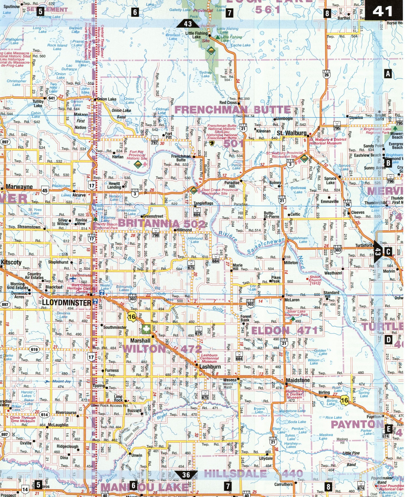
Road map Lloydminster and Vermilion surrounding area (Alberta, Canada)
Map of LLoydminster city area and Lakeland Region (Canada)
Map of LLoydminster and Lakeland Region. Detailed map of the highway and roads of LLoydminster & Lakeland Region (Alberta Canada).
Road map of LLoydminster city area and Lakeland Region (province Alberta Canada)
Map of LLoydminstercity area and Lakeland Region. Detailed map of the highway and roads of LLoydminster & Lakeland Region (Alberta Canada).
Lakeland Region
Around Lloyd minster, towns dot the prairie land-i scape on a mixed palette of boreal forests, indigo lakes, sandy beaches, and marshy wetlands. This is the heart of Alberta's Lakeland region, an area rooted in agriculture and services, and steeped in First Nations, French, and Ukrainian history. Its friendly citizens make Lakeland a warm destination year-round, but in summer people head out to fairs, festivals, u-pick farms, or the beach. The fur-trading era is remembered in local museums; key battles during the Northwest Rebellion of 1885 are documented in small historic sites.
Fort George/ Buckingham House Provincial Historic Site [A3] Alberta's earliest fur-trade history took place on the banks of the North Saskatchewan River near Elk Point, where rival traders of the Hudson's Bay Company and the North West Company set up shop in 1792. Visitors can stroll along interpretive paths, peruse the artifacts in the museum, or visit the archaeological sites of both forts.
Frenchman Butte, Saskatchewan [B7]
Five kilometers northeast of town is Frenchman Butte Historic Site, which preserves gun pits from an 1885 battle between the Cree and the North West Mounted Police. Just west of town is Fort Pitt National Historic Park, a fur-trading post from 1829 to 1890. Interpretive panels cover the fur trade and the effect the Northwest Rebellion had on Fort Pitt's residents.
Lloydminster [D5-D6]
First settled by British colonists in 1903, Lloydminster's main street forms both the 110th meridian of longitude and the Alberta/ Saskatchewan border. The Border Marker Promenade Walk interprets the history of this unusal split. The Barr Colony Heritage Cultural Centre combines diverse attractions, including a large indoor museum commemorating the mass influx of English colonists who came with Rev. Isaac Barr, the Fuchs' Wildlife display, Heavy Oil Science Centre and the Imhoff Art collection-all under one roof. Several good bird-watching sites surround the town in a region renowned for North America's few remaining turkey vulture breeding sites.
Paradise Valley [E5]
The Climb Through Time Museum, built in the former Alberta Wheat Pool elevator and grain bins, offers a unique look at growing and harvesting wheat on the Alberta prairie. As you climb the elevator, dioramas, models, and displays outline Native culture, farming, homesteading, and other aspects of rural life. A railway station has been restored and relocated nearby, and a tearoom and gift shop are also on the premises.
Vermilion [C3] Named after the red clay found in the nearby Vermilion River, this town has an urban lakeside provincial park at the end of 62nd Street that sports more than a dozen kilometers of hiking and biking trails through aspen parkland and grasslands. Firefighters come from all over the province to train at the world-class Alberta Fire Training School; plans are in the works for a Canadian Fire Museum and Discovery Centre to open in 2005. The aquatic center and gardens at Lakeland College are also open to visitors.
LOCAL LORE
The Town That Was Split in Two When the Rev. Isaac M. Barr scouted the surveyed route of the Canadian Northern railway in the fall of 1902 and decided that the intersection of the railway with the 110th meridian was the site for his dream colony, little did he know that its main street would one day be split right down the middle.
When the North West Territories were dissolved and the provinces of Alberta and Saskatchewan created by the federal government in 1905, Ottawa decided that the 110th meridian would form the border between the two, riving the village of Lloydminster in two.
Neighbors awoke to find one set of school regulations applied on one side of Main Street, and another set across the way. Motorists had two sets of driving regulations to follow, and property sales sometimes involved title searches under two jurisdictions. There were two separate municipal councils, two fire departments, and two of every other governing body. For a time, Lloydminster's biggest industry was red tape.
In 1906, the Alberta side of the community obtained village status. A year later, its Saskatchewan twin became a town. This town-village arrangement persisted for nearly 25 years. In May of 1930, by mutual government consent, the two communities merged as one town. Lloydminster achieved city status on January 1, 1958.