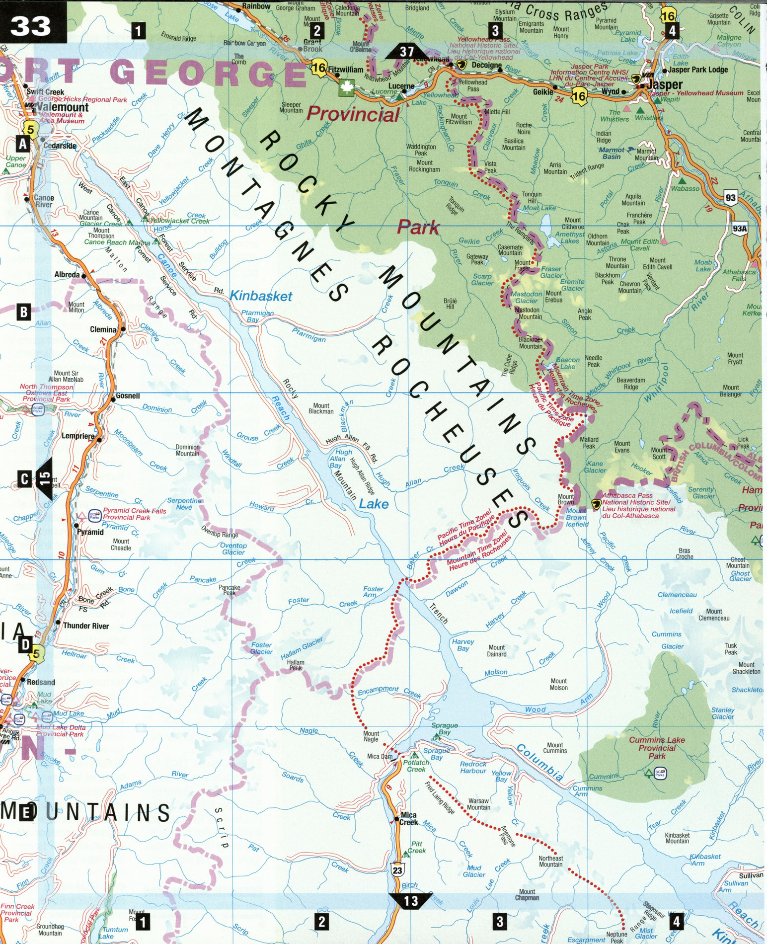
Road map Jasper National Park surrounding area (Alberta, Canada)
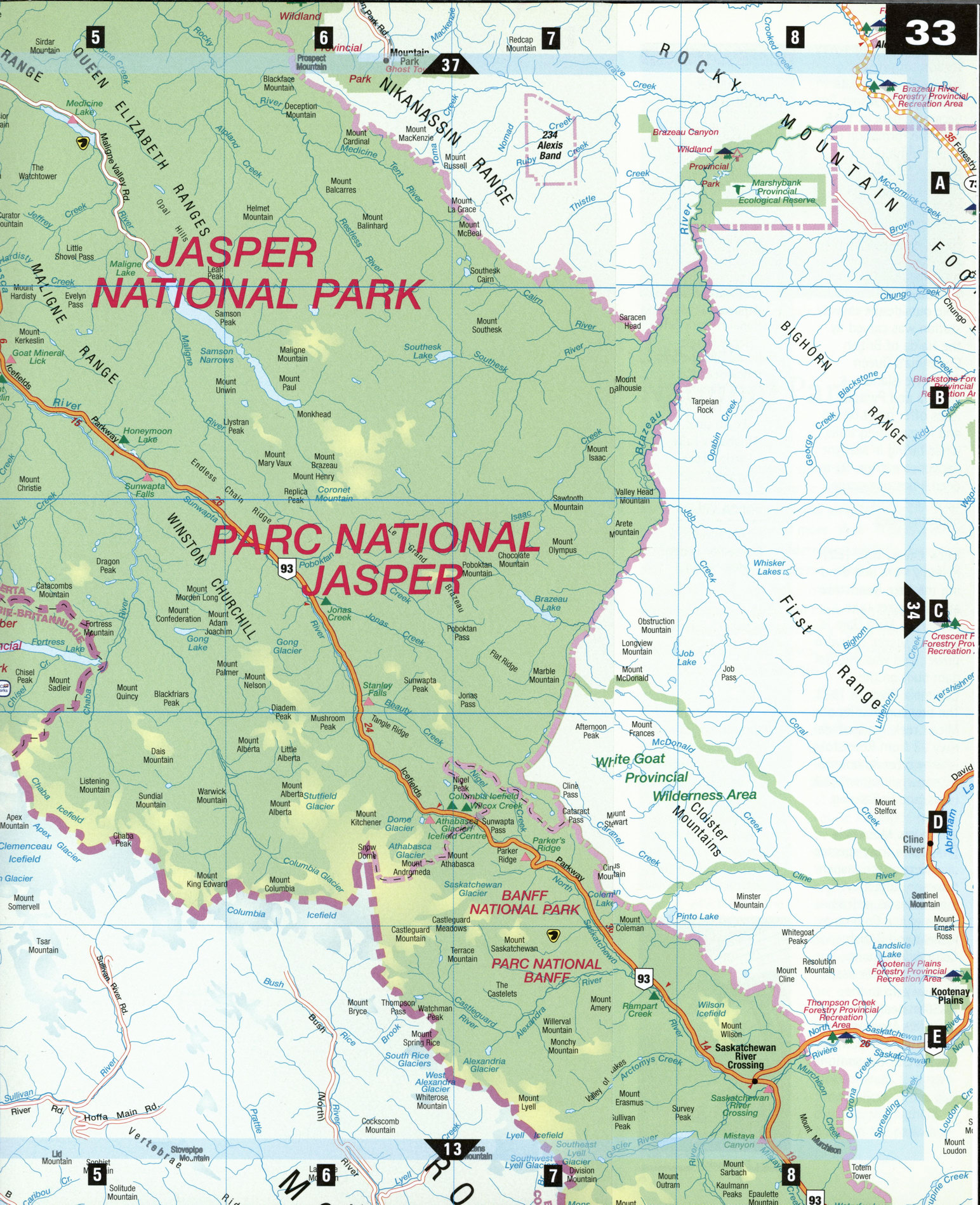
Detailed map of Jasper National Park (Alberta Canada)
Map of Jasper National Park. Detailed map of the highway and local roads of Jasper National Park with cities and towns (Alberta Canada).
Free road map of Jasper National Park (Alberta Canada)
Map of Jasper National Park. Detailed map of the highway and local roads of Jasper National Park with cities and towns (Alberta Canada).
Miette Mountain Range, Jasper National Park
Jasper National Park
Riven by the rugged spine of the Great Divide, with the wild beauty of Jasper National Park in the east and deep forests and long lakes in the west, the Jasper area covers more than 11,000 km2 of untamed mountain wilderness. Jasper's elevation and terrain provide diverse habitat for wildlife, including wolf, caribou, black bear, grizzly, elk, moose, mountain goat, and more than 2,500 bighorn sheep. Here you can walk on a living glacier, cast a line in emerald-green lakes, try heli-skiing, or hike more than 1,000 km of trails.
Athabasca Glacier [D6] On the boundary of Jasper and Banff national parks, the Columbia Icefield is a 325 km2 mass of ice and snow, the largest known south of the Arctic Circle. It is made up of eight glaciers, including the Athabasca Glacier, which faces the chalet-style Columbia Icefield Centre. On a Snowcoach Tour from the center, visitors can stand on this tongue of 1,000-year-old ice and learn about the origins of the massive glaciers. Behind the center is a tiny protected patch of Engelmann spruce, almost as old as the ice itself.
Icefields Parkway [A4-E8] The 230 km stretch of Hwy 93 from Lake Louise to Jasper, edged by glaciers along its entire length, is one of the world's most scenic highways. Many stops and lookouts reveal vistas over emerald lakes, across alpine meadows and snowy peaks. Some, like the Goat Lookout, are good places to spot mountain goats, elk, or bighorn sheep. Off the highway at Bow Pass, a short trail at Peyto Lake lookout leads to a spectacular view of this glacial lake, the highest point on the parkway.
Jasper [A4] Once a way station for prospectors, surveyors, naturalists, and trappers, Jasper first became a park in 1915 with the formation of a tent camp on Lac Beauvert. Today the town is a year-round recreation center and the heart of Jasper National Park. Old Fort Point (1811) is an early fur-trading post, while the intricate 21 m totem pole outside the railway station was carved by the Haida of British Columbia's Queen Charlotte Islands. Patricia and Pyramid lakes offer quiet hiking and horse-riding trails, while hiking in Maligne Canyon, a narrow, 50-m-deep limestone gorge, takes one close to bighorn sheep.
Mica Creek, B.C. [E2]
Rising 244 m and dividing the Lake Revelstoke and Kinbasket Lake reservoirs, Mica Dam is a major source of hydro power, and was the first dam built on the Columbia River, in 1973. The tiny community of Mica Creek, reached via Hwy 23 from Revelstoke, is known for its bountiful snowfall, snowmobile tours, and heli-skiing.
Whistlers Mountain
[A4] For a truly spectacular view of the Jasper townsite ringed by mountains as well as views of the Columbia Icefield and British Columbia's Mount Robson, take the Jasper Tramway up to the 2,250 m peak of Whistlers Mountain. A restaurant and hiking trails are at the summit.
JASPER NATIONAL PARK
Jasper Park Information Centre National Historic Site Old Fort Point Columbia Icefield Centre Athabasca Glacier Icefields Parkway Jasper Tramway Jasper Wildlife Museum Jasper-Yellowhead Museum Athabasca Pass National Historic Site
Henry House National Historic Site
Yellowhead Pass National Historic Site Maligne Lake Tours Peyto Lake Athabasca Falls Patricia Lake Pyramid Lake
MICA CREEK
Mica Dam Monashee Lodge Heli-Skiing