Road map Glacier National Park surrounding area (BC, Canada)
Road map of Glacier National Park (BC Canada)
Map of Glacier National Park. Detailed map of the highway and local roads of Glacier National Park with cities and towns.
Large scale map of Glacier National Park (BC British Columbia Canada)
Map of Glacier National Park. Detailed map of the highway and local roads of Glacier National Park with cities and towns.
Glacier National Park
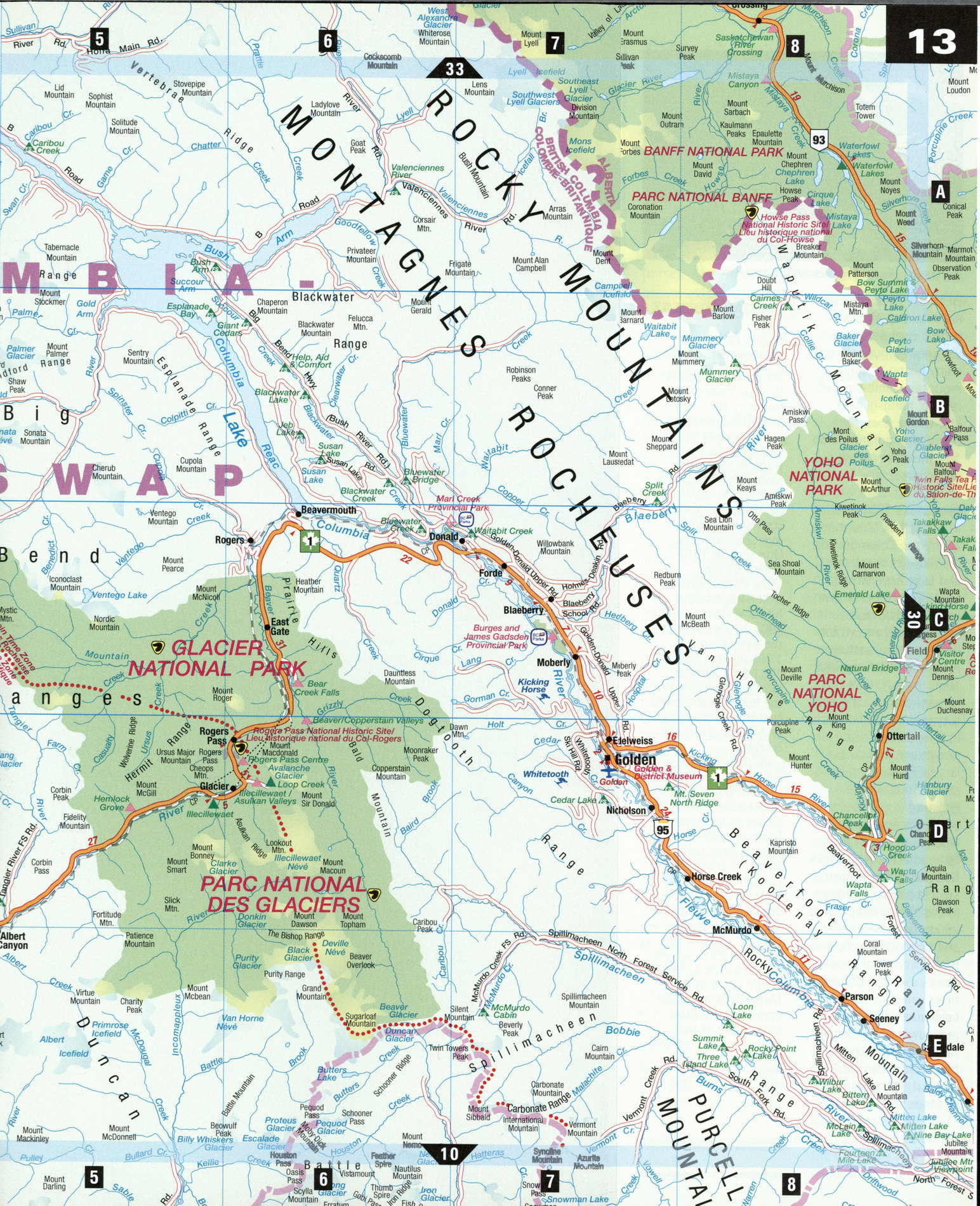
The Trans-Canada Highway encounters few regions blessed with the spectacular contrasts found around Glacier National Park: relaxing hot springs, the cold, glacier-fed waters of Kicking Horse River (according to legend, named after a stubborn pack-horse), the imposing Revelstoke Dam, and the breathtaking road between Revelstoke and Golden, which cuts across the snowcapped Selkirk Mountains and climbs up the treacherous Rogers Pass. If you're seeking nature's awe-inspiring beauty and solitude, you're in the right place.
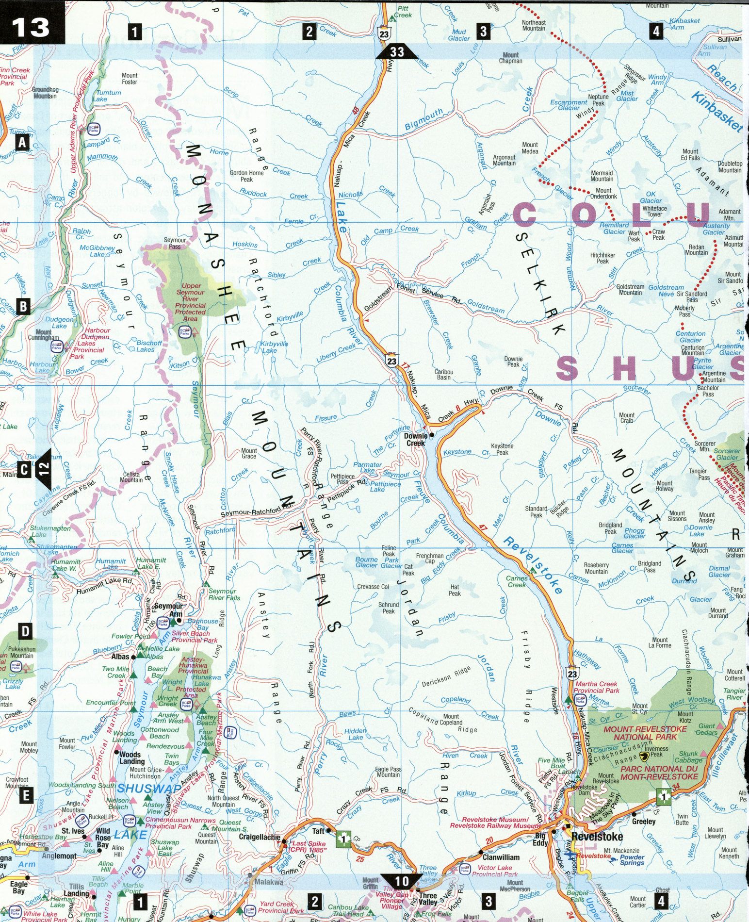
Albert Canyon [E5]
Naturally heated mineral waters are the big draw in this small roadside resort town. The Canyon Hot Springs Resort features invigorating mineral water piped to hot baths, a swimming pool, and campground. Locals also run rafting tours, trail rides, heli-skiing, and a bed-and-breakfast.
Craigellachie [E2]
On November 7, 1885, Donald Smith (later Lord Strathcona), drove the "last spike" in the Canadian Pacific Railway here. In 1927, a CPR stonemason erected a cairn to mark the spot. To commemorate the centenary, the cairn was restored with rocks collected from every province in Canada. Craigellachie is also the site of Beardale Castle Miniatureland, which has a medieval German town, an English Tudor village, a Swiss mountain village, and other Lilliputian re-creations.
Glacier National Park [D5-D6] Named for over 400 permanent glaciers, this stunning park was established in 1886 to protect the ancient, jagged Selkirk and Purcell Mountains. It also commemorates the successful completion of both the CPR and the Trans-Canada Highway, despite almost insurmountable odds. The landscape is characterized by steep, angular mountains, deep, narrow valleys, waterfalls, icefields and glaciers, and countless avalanche paths. The legendary snowfall makes it a popular, but challenging, alpine ski destination from December to April. Summer offers camping, hiking, interpretive programs, and self-guiding hikes. To get a sense of history, hike the Abandoned Rails Trail, or explore the forested ruins of Glacier House, which between 1886 and 1925 was one of the CPR's luxury hotels.
Golden [D7] At the confluence of the Columbia and Kicking Horse rivers, Golden is the gateway to five national parks. Originally a railway town, later a terminus for steamboat traffic up the Columbia River, now its ideal location among clear lakes and majestic mountains makes it a recreational paradise. Outdoor enthusiasts will enjoy hiking, cycling, mountain climbing, river rafting, hang-gliding, heli-skiing, horseback riding, and golfing on an 18-hole championship golf course.
Revelstoke [E3] Nestled in the Selkirk Mountains, where the Columbia and lllecillewaet rivers meet and Lake Revelstoke flows into Upper Arrow Lake, Revelstoke is blessed with an extraordinary natural setting. A Heritage Walking Tour takes in more than 60 elegant turn-of-the-cen-tury restored buildings in Revelstoke's historic downtown known as Grizzly Plaza, a cobblestone street whose entrance is guarded by two huge sculpted wooden grizzly statues. Bin adjacent Revelstoke National Park, the narrow, switchbacking Meadows in the Sky Parkway climbs 26 km from lush cedar and hemlock rain forests, past spectacular viewpoints over the Columbia River valley, to idyllic subalpine wildflower meadows. At Balsam Lake, walk or take the free shuttle bus for 2 km to the 1,938 m summit of Mount Revelstoke.
SPECIAL INTEREST
Rogers Pass National Historic Site
The spectacular road through Rogers Pass began in 1881, when Maj. A. B. Rogers was commissioned by the CPR to find a route through the Selkirk Mountains. Avalanches were all too eommon-by 1916, the "White Death" had killed over 250 workers. One slide in 1910 buried 63 men.
The Visitors Centre of the Rogers Pass National Historic Site [D6], at the summit of the pass (elevation 1,382 m), was built in 1983 from massive logs and is shaped like the huge snow tunnels that shelter the road and railway from avalanches.
Inside, a mockup of Rogers Pass is on display, including a running model train as it looked in the 1890s. Other exhibits illustrate railway tunnels, natural history, Glacier House in its heyday, and the Nakimu Caves, one of the largest cave systems in Canada. Outside, you can follow the 1890s rail line or rest awhile at the picnic tables by the Memorial Arch, which commemorates the completion of the Trans-Canada Highway over Rogers Pass in 1962.