Road map Barrie city surrounding area (Ontario, Canada)
Road map of Barrie area (Ontario, Canada)
Map of Barrie city area. Detailed map of the highway and local roads of Barrie city area (province Ontario, Canada).
Large scale road map of Barrie area
Map of Barrie area. Detailed map of the highway and local roads of Barrie city area (Ontario, Canada).
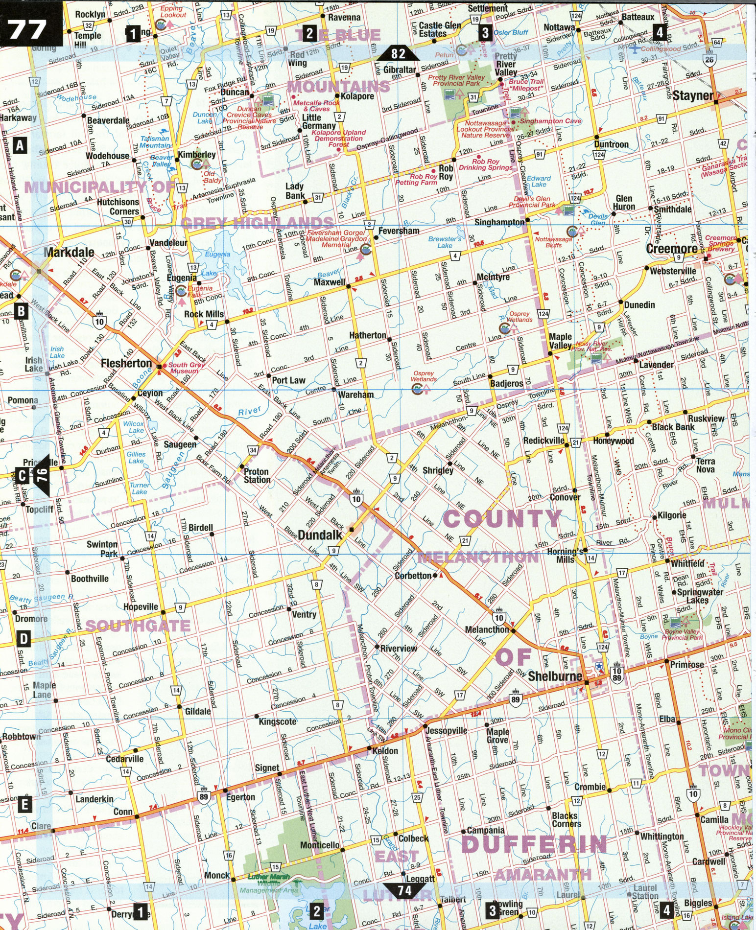
Dufferin and Simcoe Counties
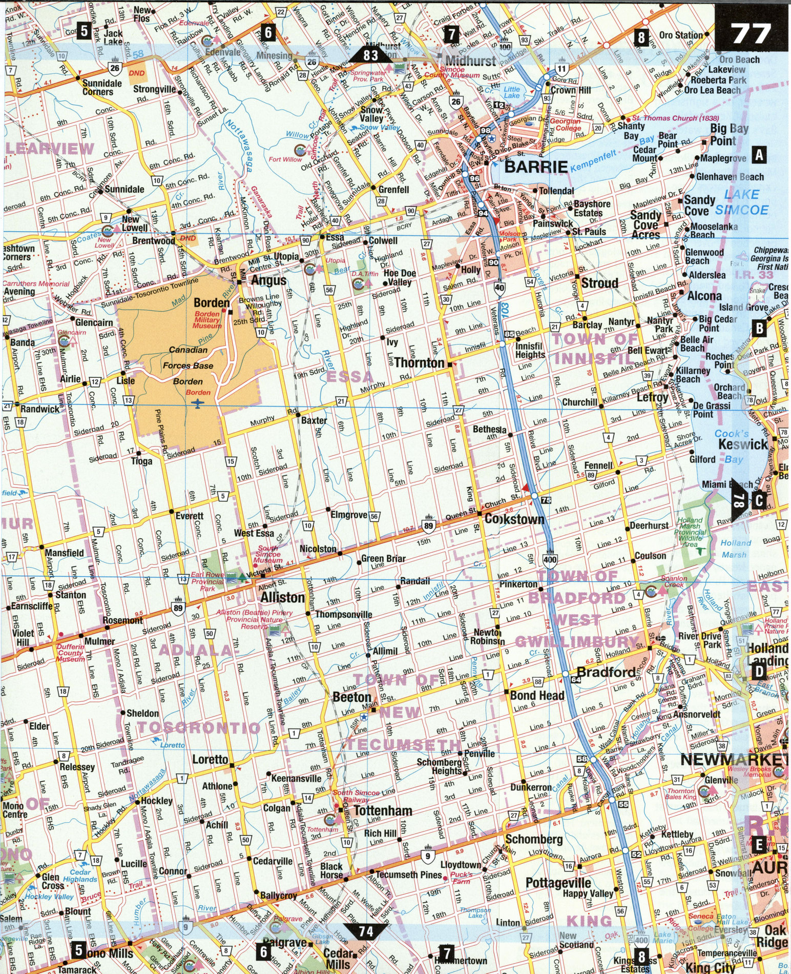
With its rough terrain and lack of large water bodies, Dufferin County was one of the last areas of southern Ontario to be settled. "The Roof of Ontario," or Niagara Escarpment, forms a dividing line through the county with the western part covered by gently rolling plains, ideally suited for agriculture. Simcoe County is dominated by Barrie and the Highway 400 corridor, the route to cottage country from Toronto. Here you can stay at a luxury resort or rent a basic beach cabin, shop for antiques in small towns or hit major malls, golf on a variety of courses or fish for lake trout, pike, or bass.
Alliston [D6] Nestled in the rich agricultural Nottawasaga Valley is Alliston, the "potato capital of Ontario," which holds an annual potato festival in August. One of the town's most famous native sons is Sir Frederick Banting, the codiscoverer of insulin. The Nottawasaga Inn is a top-ranked resort offering golf, swimming, fitness center, and full-service spa. (Э Southwest of Alliston on Hwy 89 is the Dufferin County Museum and Archives, built in the style of an Ontario bank barn. The silo functions as an art gallery space and contains a spiral staircase salvaged from the local Orangeville Jail (c. 1880). From the top floor of the silo there is a magnificent view of the Mulmur Hills and the Niagara Escarpment.
Barrie [A7] Located in the heart of the Georgian Lakelands area, Barrie was once a military post and an important fur-trading link between Lake Ontario and the upper Great Lakes. Kempenfest, Barrie's annual waterfront festival, has over 300 artisans displaying their works the first weekend in August. There is harness racing at Barrie Raceway, while the MacLaren Art Centre hosts regional, national, and international exhibitions in the visual arts.
From the downtown City Dock you can take the Serendipity Princess, a 265-passenger paddle wheeler, on a sightseeing cruise of Kempenfelt Bay's sparkling waters.
Borden [B6] The Borden Military Museum at Canadian Forces Base Borden has several heritage buildings, a memorial park, and a collection of over 9,500 artifacts, weapons, uniforms, military vehicles, aircraft, and mementoes. Camp Borden was established in 1916, and half of all Canadian soldiers who served in both world wars were trained here.
Midhurst [A7] The Simcoe County Museum charts local development from prehistoric times to the present. There are displays and artifacts from Native cultures-including an 1834 long-house-antique machinery, and a 19th-century Victorian village street, complete with store, toy shop, and undertaker's parlor. Nearby Springwater Provincial Park provides picnic shelters, children's play areas, wildlife displays, and hiking and skiing trails.
Shelburne [D4] This quiet town becomes "Fiddleville" every August when it hosts the Canadian Open Fiddle Championship. The local population swells by more than 10,000 over the three days as fans and contestants attend the largest fiddle contest in North America.
Tottenham [E6] The South Simcoe Railway offers open-window coach rides through the Beeton Creek valley, powered by steam locomotives dating from 1883 and 1912.
SPECIAL INTEREST
The Niagara Escarpment Biosphere Reserve
The Niagara Escarpment Biosphere Reserve encompasses 190,000 hectares between the Niagara River and the tip of the Bruce Peninsula, and protects several key areas along the Niagara Escarpment with natural geomor-phological features that are vulnerable and easily damaged. At Duncan Crevice Caves Provincial Nature Reserve [A2], seasonal extremes in temperature and the forces of gravity have caused large blocks of rock to break away from the face of the Niagara Escarpment. The gradual shifting downward of these huge blocks has produced large caves.
At Pretty River Valley Provincial Park [A3], the land bears the marks of a retreating glacier-meltwater channels, moraine, outwash, and till. The escarpment geology highlights several good crevice caves.
Mono Cliffs Provincial Park [E4-E5] contains crevice caves, an upland limestone plain, and talus slopes. The park features two prominent masses of rock, separated by erosion from the main rock body, called outliers. Botanists have noted that the local vegetation includes a rich diversity of ferns.
At the Hockley Valley Provincial Nature Reserve [E5], the Nottawasaga River cuts a picturesque gorge across the escarpment. Forested moraines and open meadows lie upstream, and swamp and bottomland forest spread across the valley floor, stretching for several kilometers.