Road map Robson Valley surrounding area (BC, Canada)
Road map of Robson Valley (BC Canada)
Map of Robson Valley (British Columbia, Canada). Detailed map of the highway and local roads of Robson Valley with cities and towns.
Large scale map of Robson Valley (BC Canada)
Map of Robson Valley (British Columbia, Canada). Detailed map of the highway and local roads of Robson Valley with cities and towns.
Robson Valley
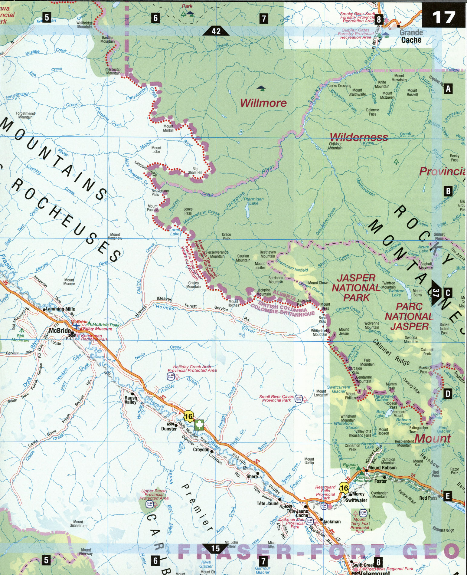
The dramatic, glacier-gouged Rocky Mountain Trench is the longest valley in North America, ranging from 3 to 16 km wide, and spanning 1,600 km from British Columbia's northern border to Montana in the U.S. To the west lie the jagged peaks of the Cariboo and Columbia mountains, to the east the even grander Rockies, and running along the flat floor of the Robson Valley are thin ribbons of water, asphalt, and steel-the Fraser River, the Yellowhead Highway, and the Canadian National Railway line. The Yellowhead Highway junction at Tete Jaune Cache offers a choice of destinations: north to Prince George, south to Kamloops, or east to Jasper.
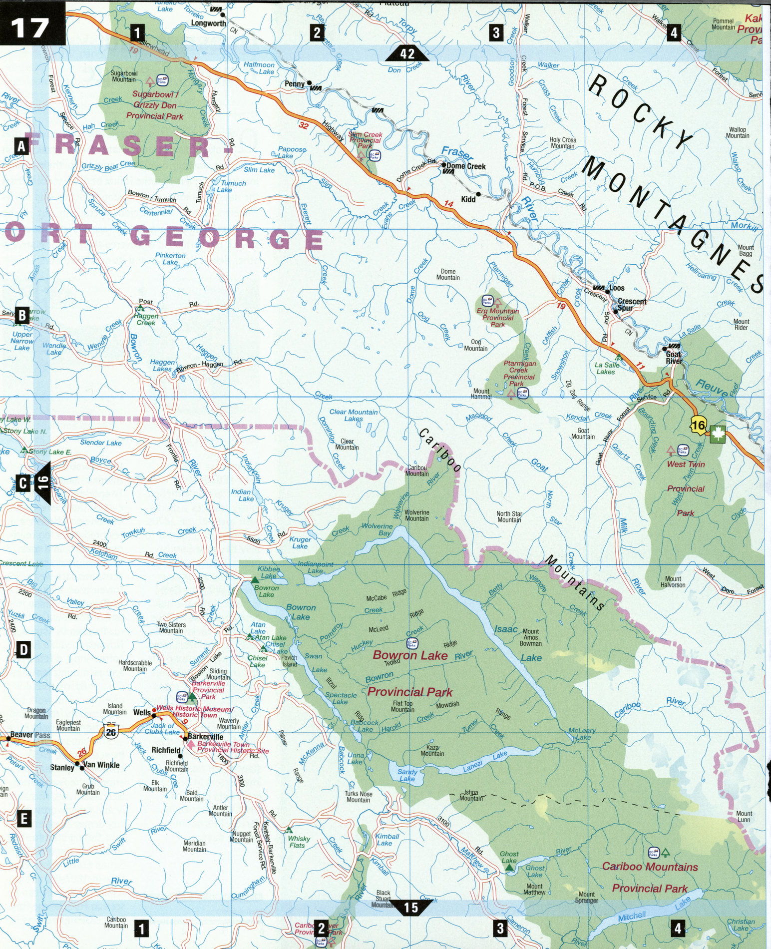
Bowron Lake Provincial Park [D2-D3] On the western slopes of the Cariboo range, this park is known internationally for its 7- to 10-day, 116 km canoe circuit, which takes paddlers through six lakes (Bowron, Indianpoint, Isaac, Lanezi, Dandy, and Spectacle), two rivers, and other waterways back to the starting point. Canoe carts are provided along 11 km of portages. Reservations are necessary. Terrain in Bowron Lake includes the rounded hills of the Quesnel Highlands and the more rugged mountains in the east. Caribou, mountain goats, and grizzly bears can be seen at higher elevations, while the lakes are stocked with steelhead trout, Dolly Varden and kokanee salmon. There are also walking trails near the campground.
Kakwa Provincial Park [A4-A5] This remote wilderness area located on the border with Alberta showcases ice-clad mountains, broad alpine meadows, and a section of the Continental Divide. Summer activities include camping, hiking, fishing, and horseback trips; in winter, snow-mobiling and wilderness ski tours. Wilderness camping is permitted, but facilities are limited. Above all don't forget your binoculars-wildlife species found in Kakwa include grizzly and black bears, caribou, elk, wolves, bighorn sheep, mountain goats, wolverine, and marten. The park can be accessed from Walker Creek Forest Service Road or by air charter.
McBride [C5] Not much but the splendid beauty of nature lies along the Yellowhead Highway except for McBride, nuzzled deep in the Robson Valley. McBride began as Railway Siding 39 but now provides services to farmers and ranchers in the area and welcomes backcountry adventurers who come to paddle, heli-ski, or snowmobile. Horseshoe Lake has a bird-viewing platform from which to see blue herons and bald eagles.
Tete Jaune Cache [E7]
Yellowhead highways 5 and 16 split at the tiny hamlet of Tete Jaune Cache, one fork winding southwest to Kamloops, the other northwest to Prince George. "Tete Jaune" (French for yellow head) was the nickname given by French voyageurs to Pierre Hatsinaton, a fair-haired, dark-skinned Iroquois trapper and guide who worked for the Hudson's Bay Company in the early 1800s. A boomtown of 5,000 people in the early 1900s, Tete Jaune Cache was the navigation center for stern-wheelers hauling passengers and freight along the Fraser River to Prince George. Bits and pieces from its stern-wheeling days can still be seen around town.
SPECIAL INTEREST
Fraser River Salmon
The mighty Fraser River begins in the Rockies near the Alberta border, carving deep gorges and broad valleys on its 1,370 km route to Vancouver and the Pacific. Every year millions of salmon migrate inland from the west coast upstream to their home river estuaries to spawn, and the Fraser has one of the highest runs in the world with some 10 to 20 million salmon returning home. Rearguard Falls Provincial Park, just outside Tete Jaune Cache, represents the northernmost point of the Fraser salmon run. Bald eagles, seals, sturgeon, and bears feed on the salmon, offering ample opportunity for wildlife watching on various spots along the river.
Continental Divide
Every continent except Antarctica has a continental divide, a line that divides which way water flows. North America's Continental Divide runs from northwestern Canada along the spine of the Rocky Mountains south through Waterton National Park down to New Mexico. The Yellowhead Pass, 1,131 m above sea level, is one of the lowest gaps along the entire Continental Divide. Rain or snow draining on the east of the divide flow into the Arctic Ocean via the Miette, Athabasca, and Mackenzie rivers. West of the divide, runoff feeds the Fraser River flowing into the Pacific.