Road map Brooks and Okotoks surrounding area (Alberta, Canada)
Road map of Okotoks and Brooks city area (Canada)
Road map of Okotoks and Rocky Mountain Foothills (Alberta Canada). Detailed map of roads of Okotoks & Rocky Mountain Foothills.
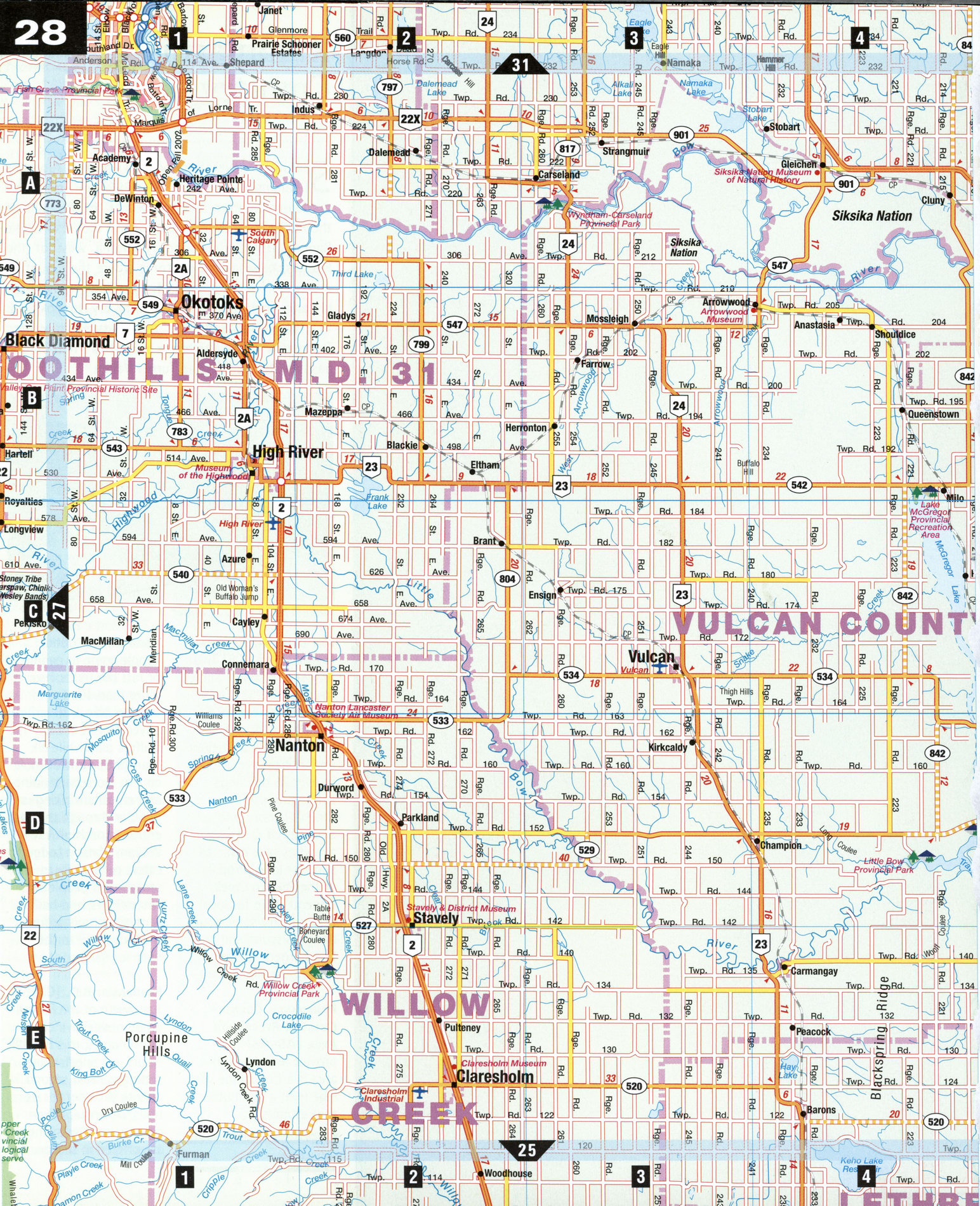
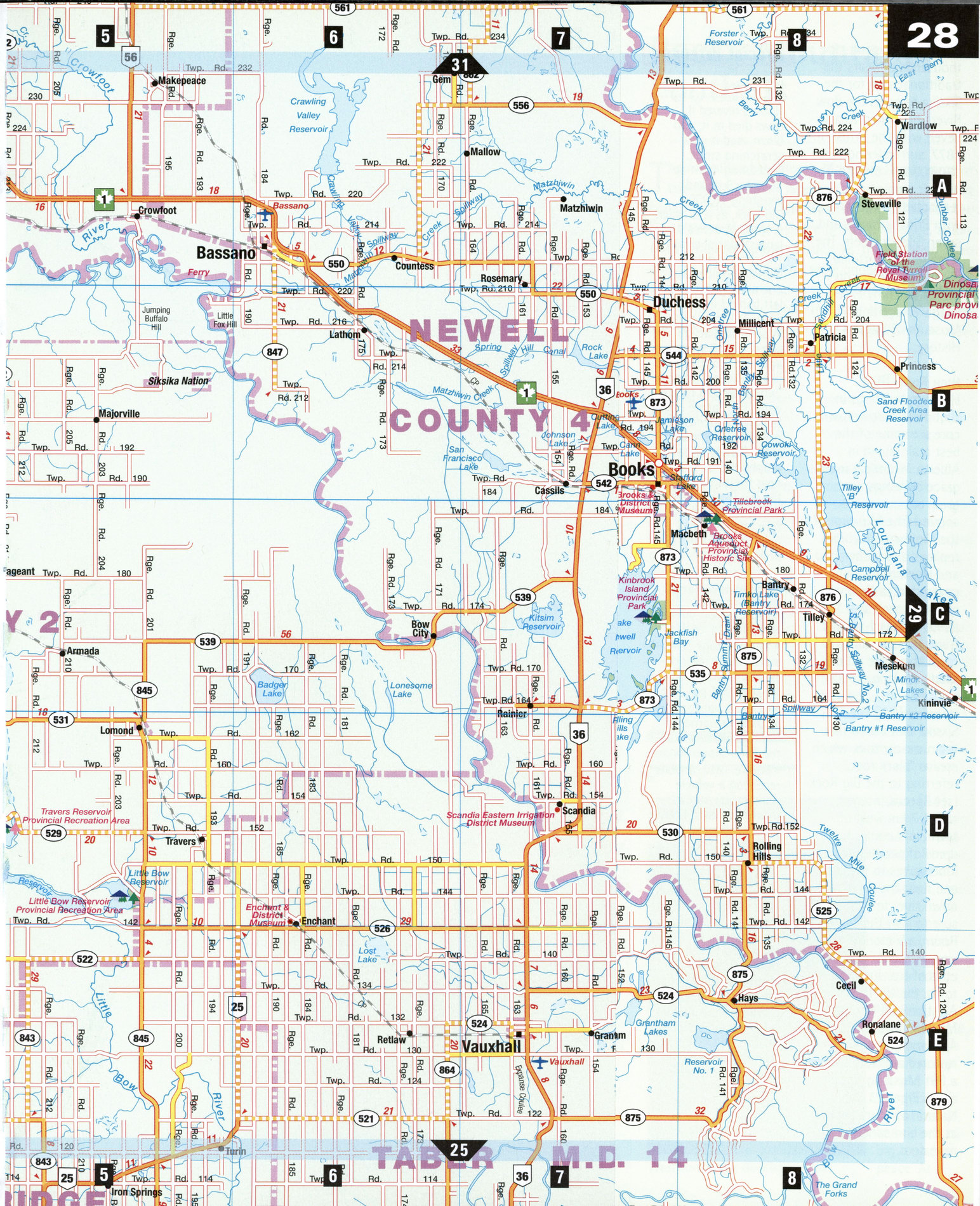
Road map of Okotoks city area and Brooks city area (Canada)
Road map of Okotoks and Rocky Mountain Foothills (Alberta Canada). Detailed map of roads of Okotoks & Rocky Mountain Foothills.
Rocky Mountain Foothills
The foothills of the Rocky Mountains have some of the finest grazing land in Canada, and ranching began in the region shortly after the arrival of the North West Mounted Police in 1874. Massive, ambitious irrigation projects such as the Bassano Dam and the Brooks Aqueduct were undertaken here, and many of the towns, such as Okotoks, have a decidedly quirky history. While traces of the area's ranching past remain, today farmers produce a wide variety of crops in the shadow of the Rockies.
Bassano [A6] The town of Bassano has a number of unique claims to fame. Named after the Marquis of Bassano, Italy, who owned shares in the Canadian Pacific Railway, the town was the first RCMP training center for its canine units, and Canada's first flying doctor flew out of Bassano. The 24-spillway Bassano Dam, now a historic site, was once the most important structure of its kind in the world, due to a combination of character, length, unusual foundation, and water depth.
Brooks [B7] Five kilometers east of Brooks, visitors may take guided tours to see the engineering marvel of Brooks Aqueduct, a 3-km-long canal once used for irrigation. When it opened in 1914, it was the longest steel-reinforced concrete structure of its kind in the world. Brooks also has a pheasant hatchery, The Canadian Pheasant Company, which raises various species of pheasants for release in the province.
Cluny [A4]
South of Cluny, on the Siksika Nation Reserve, the grave of Crowfoot, chief of the Siksika (Blackfoot), is marked with a metal cross engraved "Father of His People." Crowfoot's life as a warrior began at age 13, and he fought in 19 battles before becoming a man of peace. At Blackfoot Crossing-for thousands of years the traditional spot for the Siksika to cross the Bow River-he signed Treaty Seven with the British in 1877, surrendering some 130,000 km2 of land. The historic signing was reenacted 100 years later with Prince Charles and seven Siksika chiefs. The remains of a fortified Siksika village are preserved as Cluny Earth Lodge Village and Museum of Natural History.
High River [B1]
Heritage buildings in High River's downtown core are some of the best maintained in Alberta. Historical murals grace buildings, and great antique shops abound. The Museum of the Highwood includes replicas of a barbershop and blacksmith shop covered in cattle brand marks, as well as a 1950 passenger-and-freight train. Harness shops in town show the art of saddle making.
Okotoks [Bl] The Siksika first called this town sik-okatoks, which means "black rock," referring to the Big Rock (see Special Interest, right), 1 km west of town. In summer hundreds of people take inner tubes to the rock and float the three hours down river to town. Be sure to visit the Ginger Room, a Victorian mansion with over 40 varieties of tea. Just east of town, the Northwest Aviation and Heritage Museum at the Okotoks Air Ranch houses restored artifacts such as a P51 Mustang fighter and a Piper C3 Cub. Natural aviators abound at the bird sanctuary next door.
SPECIAL INTEREST
Big Rock
Natives revered it, cows died in it, and bison used it as a scratching stone. Measuring 40 m by 18 m by 9 m and weighing 18,000 t, Big Rock, as it is called, is North America's largest glacial erratic. The sharp-angled leaning boulder was one among thousands left behind in the wake of the ancient Wisconsin glacier some 10,000 years ago. The Stoney called it ipabitunga-ingay, or "where the big rock is," while the Sarcee called the area chachosika, or "valley of the big rock." Native picto-graphs can be seen near the top. In 1978, the Big Rock became the first natural feature recognized as a provincial historic site in Alberta.
Odd Okotoks Facts
Okotoks last buffalo was killed in 1879. •To encourage ranching in 1880, the government leased land for one cent per acre. •In 1902, oats grown in Okotoks garnered the highest award at the Paris Exposition. •Before 1912, anyone receiving a vehicle registration had to make their own license plate.
•The Sandstone Brick Plant once had a steam boiler with an overabundance of hot water. Local businessmen used a bathtub there to freshen up-until it was used to thaw a headless corpse for an autopsy. •Prospectors staked numerous unsuccessful gold claims in the 1920s when a local woman allegedly discovered a nugget in the goose she was stuffing for dinner.