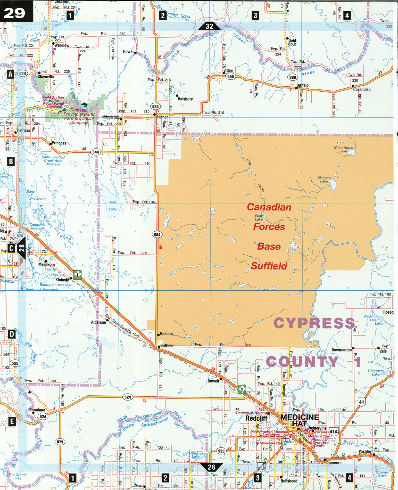
Road map Medicine Hat and Great Sand Hills surrounding area (Alberta, Canada)
Road map of Medicine Hat city area and Great Sand Hills city area (Canada)
Map of Medicine Hat and Great Sand Hills city area. Detailed map of the highway and roads of Medicine Hat city area and Great Sand Hills city area (Alberta Canada).
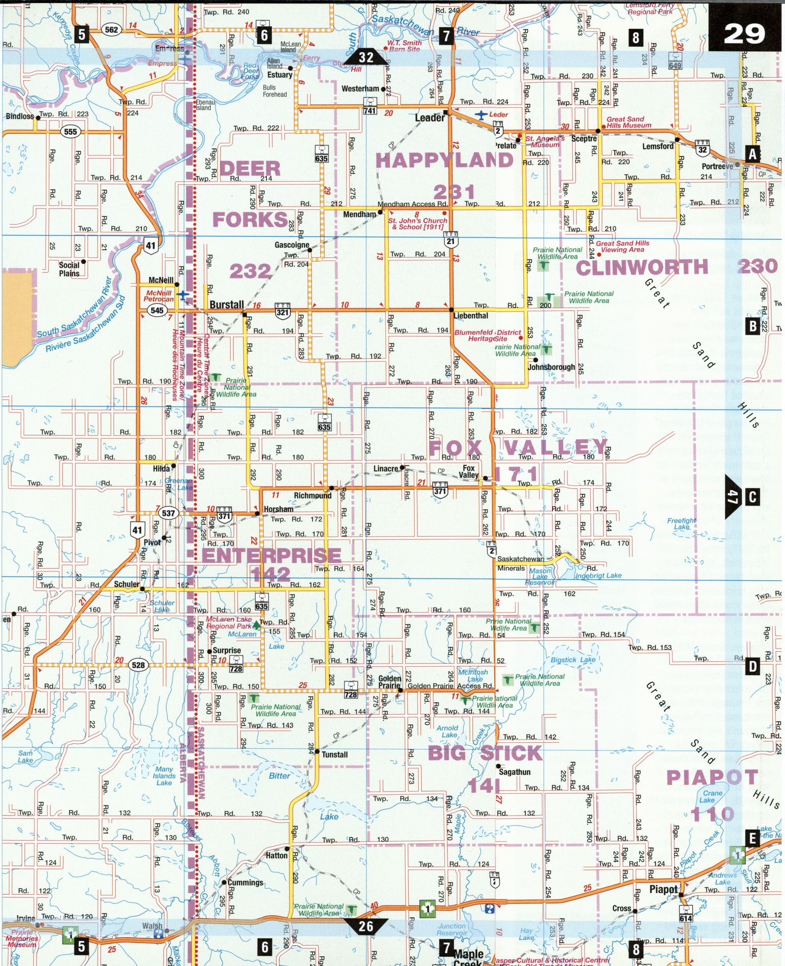
Free detailed map of Medicine Hat city area and Great Sand Hills city area (Canada)
Map of Medicine Hat and Great Sand Hills city area. Detailed map of the highway and roads of Medicine Hat city area and Great Sand Hills city area (Alberta Canada).
Great Sand Hills
Just across the Alberta border, ^ ; southwestern Saskatchewan is home to one of the most unlikely land scapes in Canada-the Great Sand Hills, 1,900 km2 of shifting, windswept sand dunes that are actually the remains of the vast delta of an ancient glacial river. The hills are just one of the fascinating natural attractions in this frontier area bisected by the Saskatchewan and Red Deer rivers, a land of unusual wildlife, deep aquifers, natural gas, and rich clay, where dinosaurs once walked the earth.
Dinosaur Provincial Park [A1] Seventy-five million years ago, when Alberta was a subtropical coastal plain, more than 30 species of dinosaurs thrived here. During the last 20 years, over a 27 km stretch of the Red Deer River, paleontologists have discovered more than 300 dinosaur skeletons. The park, now a UNESCO world heritage site, protects one of the world's most extensive fossil beds, and ongoing research is carried out at the Royal Tyrrell Museum Field Station. Guided walks and bus tours through the badlands are available and are the only way to see this otherwise off-limits landscape.
Leader, Sask. [A7]
Leader is a quiet service town with echoes of old rural Saskatchewan. Six kilometers west of town stands W.T Smith Barn, once North America's largest barn at 122 m by 206 m by 18 m. Built in 1914 and dismantled in 1921, the original foundation remains, along with a scale model. The Estuary Hutterite Colony, also west of town, offers a tour which reveals that sect's communal way of life involving church, school, and work. In town, local fauna in the Great Sand Hills is depicted in five large wildlife sculptures: mule deer, burrowing owls, prairie rattlesnakes, ferruginous hawks, and kangaroo rats.
Medicine Hat [E3]
Founded in 1883 when the Canadian Pacific Railway discovered huge reserves of natural gas (downtown street lamps are still lit by natural gas), Medicine Hat is known for its stoneware and clay pottery. The Clay Products Interpretive Centre and Medalta Potteries National Historic Site trace the history of the local pottery industry. The Saamis Tepee and Archeological Site holds the giant 58 m tepee built for the 1988 Calgary Winter Olympics to commemorate the vital role of Native peoples in southern Alberta's history, while Echo Dale Farm and Regional Park has animals and pioneer demonstrations, as well as the Ajax Coal Mine and Woolfrey House, Dinosaur Provincial Park a two-story log cabin built in 1887.
Redcliff [E3] Green thumbs will love Redcliff. Among the towns with the most daylight in Canada, it is a prime location for the numerous greenhouses situated here. Once called the "Smokeless Pittsburgh of the West," Redcliff started life as an industrial center after a coal mine west of the town was developed in 1883. The town grew and prospered with the discovery of more coal and natural gas reserves. By 1911, more than 20 industries, including a shoe factory, crayon factory, brick plant, knitting factory, and cigar maker, were in operation.
Sceptre, Sask. [A8]
The Great Sand Hills Museum features a typical street that preserves the heritage of the area surrounded by Saskatchewan's most famous desert. To reach the Great Sand Hills themselves, travel 1.6 km west of Sceptre on Hwy 32, then head south on the unmarked grid road for 18 km to the Great Sand Hills. Look for 20 pairs of old cowboy boots nailed to a fence. Visitors can explore the active dunes, some as high as 25 m and shifting eastward 4 m a year.
ATTRACTIONS
LEADER
W.T Smith Barn Estuary Hutterite Colony Leader Sculptures Leader Millennium Gardens Checkerboard Hill Blumenfeld Church (1915)
MEDICINE HAT
Clay Products Interpretive Centre Medalta Potteries National Historic Site Echo Dale Farm and Regional Park Ajax Coal Mine Woolfrey House Riverside Park St. Joseph's Sculpture Park Medicine Hat Museum and Art Gallery Downtown Historic Walking Tour Saamis Tepee and Archeological Site
SCEPTRE
Great Sand Hills Museum