Road map Lethbridge city surrounding area (Alberta, Canada)
Road map of Lethbridge city area and Southwestern Alberta
Road map of Lethbridge and Southwestern Alberta province. Detailed map of
the highway and roads of Lethbridge & Southwestern Alberta (Canada).
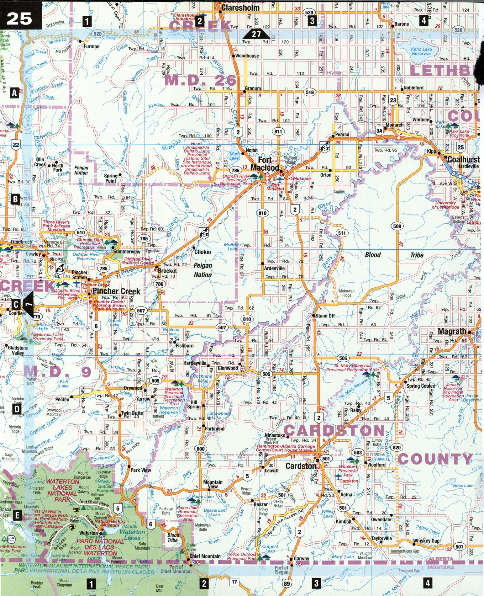
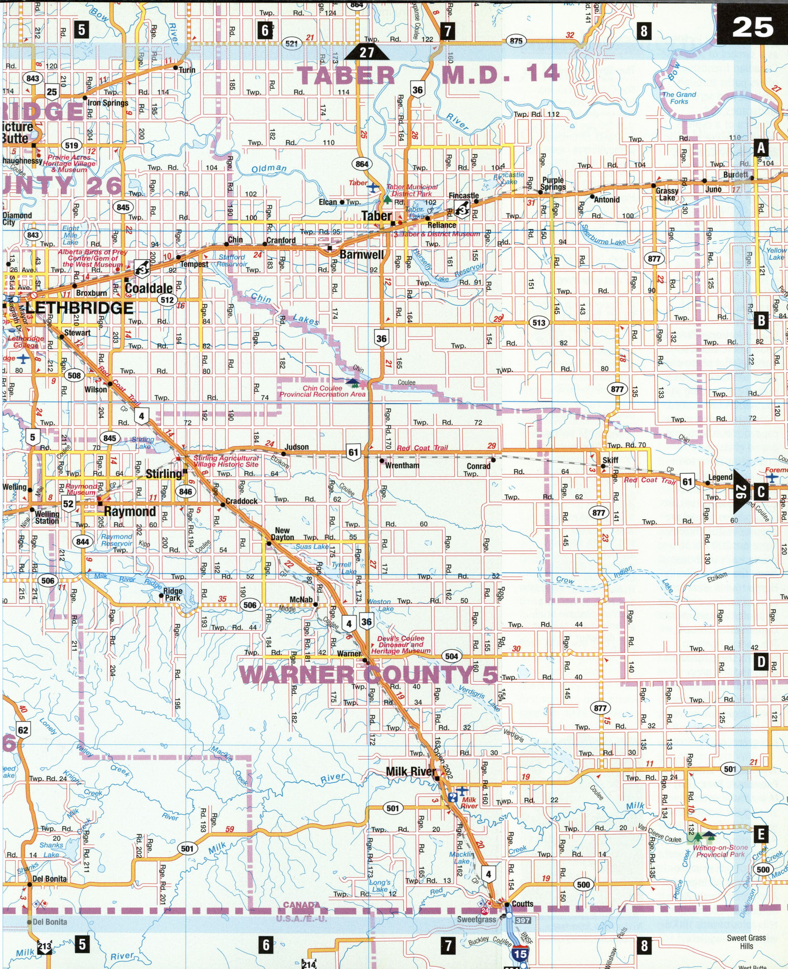
Free map of Lethbridge city area and Southwestern Alberta
Southwestern Alberta mapRoad map of Lethbridge and Southwestern Alberta province. Detailed map of the highway and roads of Lethbridge & Southwestern Alberta (Canada).
Sandwiched between the Rocky Mountains to the west and Cypress Hills farther east, the dry, chinook-swept region of southwestern Alberta is a land of coulees (dry gullies) and eerie hoodoos (rock pillars) that change colors with the sun, a land of reservoirs and long lines of wheeled sprinklers. Nearly half of all of Canada's irrigation systems are here, necessary to grow canola and the area's major crop, sugar beets. Oil wells are also a common sight in this resource-rich region, as are the marks of a history entwined in Plains Indian hunts, sacred native cliffs, and whiskey trading.
Cardston [D3]
Cardston's Mormon beginnings in 1887 can be seen in the stunning Alberta Temple, a white granite landmark that was the first temple built by the Mormon Church outside of the U.S. The Remington-Alberta Carriage Centre features North America's largest (more than 200) collection of horse-drawn vehicles, including carriages used by Queen Elizabeth II. Don't miss Fay Wray Fountain, which pays tribute to this Cardston's most-famous citizen.
Fort Macleod [B3] At the edge of southwestern Alberta's oldest town is a replica of the first western post established in 1874 by the North West Mounted Police, today the RCMP Visitors can view native, pioneer, and police history exhibits or participate in vignettes. A law office, blacksmith's shop, and medical-dental center complete with foot-operated drill and primitive X-ray machine are all on display.
Head-Smashed-in Buffalo Jump Provincial Historic Site [B2] At this UNESCO world heritage site, members of the Blackfoot Nation interpret the hunting technique of herding buffalo over cliffs, practiced by their predecessors for 6,000 years. The interpretive center, built into the cliffside, has 11 m of ancient stone and tool beds, making it one of North America's largest native archaeological sites. Seven levels of exhibits, films, trails, and dioramas tell the history and culture of the Blackfoot Nation.
Lethbridge [B5] Overlooking the wide Oldman River, Alberta's third largest city was founded as a coal-mining town in 1870 and now is a major agriculture and oil and gas center. Fort Whoop-Up in Indian Battle Park re-creates a notorious American-run fort where ingredients in illegally sold liquor included anything from chewing tobacco and Jamaican ginger to red pepper. High Level Bridge spans the Oldman River valley, at one point reaching 95.7 m above the river. The Nikka Yuko Japanese Garden, opened in 1967 as a symbol of Japanese-Canadian friendship, offers paths through intricate and serene landscapes and a replica of a cypress wood Japanese pavilion. In nearby Coaldale, the 28-hectare Alberta Birds of Prey Centre provides a tour, including flying demonstrations, of captive breeding and rehabilitation facilities for falcons, owls, hawks, and bald eagles.
Waterton Lakes National Park [E1]
Joined with Montana's Glacier National Park in 1931 as the world's first international peace park, Waterton Lakes holds a magnificent setting in southern Alberta, filled with cobalt lakes, snowcapped mountains, and prairie grasslands. Cruises on Waterton Lake or canoe and paddleboat rentals on gorgeous Cameron Lake (a subalpine cirque) are popular visitor choices. There are 200 km of hiking trails to choose from; the 2.8 km Bear's Hump trail is ideal for active families, and leads to a lofty viewpoint over Upper Waterton Lake. The park is home to bighorn sheep, grizzly bear, and the grey-crowned rosy finch. Red Rock Canyon features 20-m-high canyon walls streaked with red, purple, green, and yellow.
Writing-on-Stone Provincial Park [E8]
In a natural setting among the hoodoos and grasslands flanking Milk River, this park holds North America's largest group of native petro-glyphs and pictographs. A restored North West Mounted Police outpost tells tales of late 1800s whiskey smugglers.
SPECIAL INTEREST
The Cowboy Trail
The Cowboy Trail-no horse required-is a 700 km driving route that follows highways 5, 6, and 22 through prime Alberta ranching country along the foothills of the Rockies from Cardston through Pincher Creek as far north as Rocky Mountain House. Relive the Old West through rodeos, powwows, horseback riding, and trail rides. To rest your tired spurs, you can stay at Bloomin' Inn Guest Ranch, The Great Canadian Barn Dance, Lyndon Creek Cottage, or many other working ranches. For more information, call 1-800-661-1678.
Dinosaur Heritage
In Warner, at the Devil's Coulee Dinosaur Heritage Museum [D6], visitors can see the world's largest dinosaur nesting site, discovered in 1987. A guided hike leads walkers to the nesting site, which contains an intact embryo. The museum's displays include full casts of a Hypacrosaurus embryo and nest, as well as a brachylophosaur skull, an ankylosaur tail club, and dinosaur footprints.