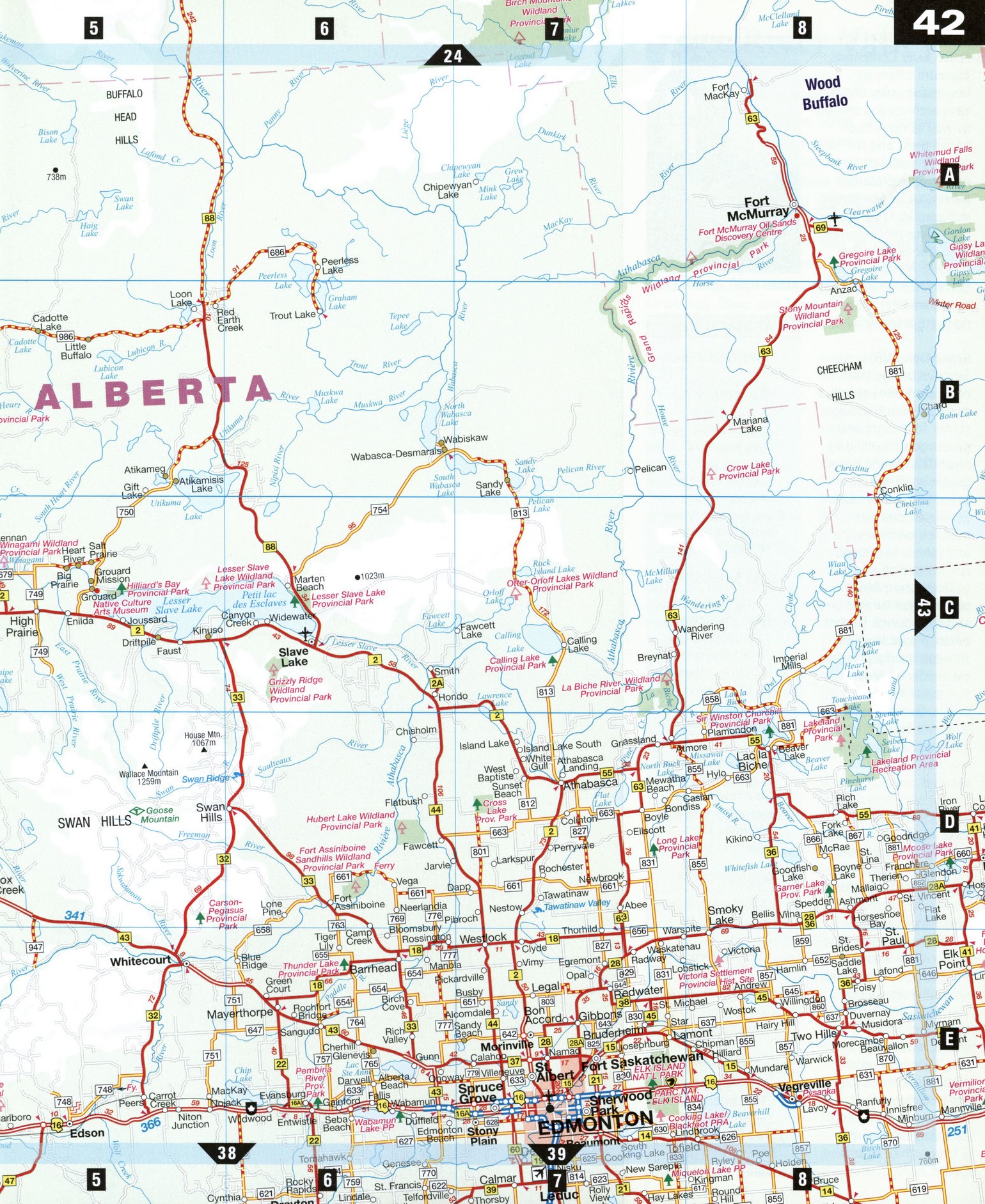
Road map of Dawson Creek and Edmonton surrounding area (Alberta, Canada)
Map of Grande Prairie city area and Fort St John city area (Alberta Canada)
Map of Grande Prairie and Peace River Valley. Detailed map of the
highway and local roads of Grande Prairie & Peace River Valley (province Alberta Canada).
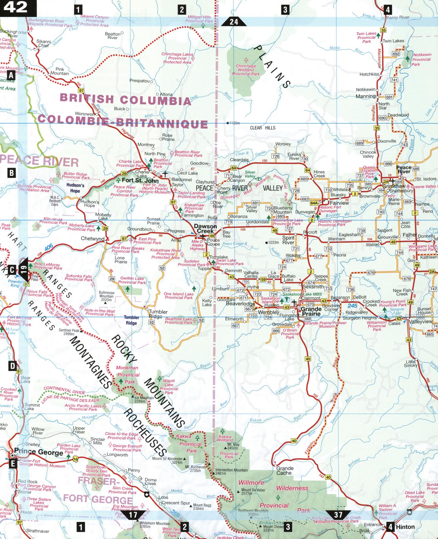
Road map of Grande Prairie city area and Fort St John city area (Alberta Canada)
Map of Grande Prairie and Peace River Valley. Detailed map of the highway and local roads of Grande Prairie & Peace River Valley (province Alberta Canada).
Peace River Valley
Oil, water, and timber drive the economy in Alberta's northwest corner, still a virtually unspoiled wilderness of roaring waterfalls and spectacular valleys. Flowing from British Columbia, the Peace River forms one of the world's largest river systems, and contributes 40 percent of Alberta's hydroelectricity. The Peace cuts an imposing valley across Alberta, with 300 m cliffs in spots and broadening to 11 km across, and eventually joins the Athabasca, Slave, and Mackenzie rivers before emptying into the Beaufort Sea almost 2,000 km away.
Dawson Creek, B.C. [C2] A cairn in the middle of town marks the Mile 0 milepost for the Alaska Highway, which winds 2,400 km northwest to Fairbanks, Alaska. The road was originally built starting in 1942 to ship supplies to the U.S. military in Alaska. The Dawson Creek Station Museum holds the tourist information center and a museum with interesting railway memorabilia and wildlife dioramas, including a mastodon tusk found on a nearby riverbank. The tourist information center and art gallery is housed uniquely in a renovated 1930s grain elevator.
Fort McMurray [A8]
Oil put this northern Alberta town on the map. The Oil Sands Discovery Centre reveals how Canadian technology turned prehistoric shale into oil near the world's largest oil sands deposits. Tours through the Syncrude plant emphasize the colossal size of the equipment and operations. Completely surrounded in wilderness, Fort McMurray also ranks as Canada's largest outpost for fly-in lodges catering to anglers, photographers, and outdoor enthusiasts.
Grande Prairie [C3]
Crystal Lake Waterfowl Refuge boasts North America's second-largest population of once-endangered trumpeter swans. Visitors can tour the Weyerhauser Pulp and Saw Mill for insight into the forest industry. Wildlife displays, pioneer artifacts, and dinosaur bones may be viewed at the Pioneer Museum. North of town, murals and 1930s storefronts can be seen in Sexsmith.
Hudson's Hope, B.C. [B1] Explorer Simon Fraser established a trading post here in 1805. Dinosaur fossils, stone tools, trapping, and coal-mining artifacts are on view in the local museum. In the 1960s, hydroelectricity saved the town, in decline after the demise of the fur trade. Interactive exhibits at the W.A.C. Bennett Dam illustrate power generation and transmission at this huge 183 m dam. Just 6 km downstream, the Peace Canyon Dam visitor center has hydroelectric exhibits and dinosaur displays.
Peace River [B4] The Peace River Centennial Museum offers an impressive collection of early archives and photos, as well as exhibits on native dress and the fur trade. A model of Fort Fork, where explorer Sir Alexander Mackenzie wintered in 1792-93, has a fireplace reconstructed with stones from the original. A cruise along Peace River is a good way to see wildlife; jetboat rides are also available.
Slave Lake [C6]
Situated on the shore of Lesser Slave Lake, this town was once a major center for freight and passengers traveling by steamboat to the Yukon goldfields. North of town, Lesser Slave Lake Provincial Park has beaches, wetlands, and forests to explore. A 7 km stretch of sand at Devonshire Beach boasts great sunsets and high dunes. Further north, a road leads up through a lodgepole forest to Marten Mountain summit at more than 900 m. Fishing boats are available for rent to try your luck at landing a few northen pike or walleye.
Willmore Wilderness Park [E3] Covering 4,600 km2 of untamed hinterland on Jasper National Park's northern border, Willmore Wilderness Park is prime wildlife watching territory. No roads lead into the park, but if you hike, ski, or horseback ride you can glimpse mountain goats, bighorn sheep, moose, caribou, and black bear on the craggy peaks and along the wild rivers. Best access is from the Rock Lake Recreation Area, 6 km north of Grande Cache.
ATTRACTIONS
DAWSON CREEK
Dawson Creek Station Museum
Mile 0 Post Northern Alberta Railway Park Alaska Hotel Walter Wright Pioneer Village Grain Elevator Annex Tourist Information Centre and Art Gallery
FORT McMURRAY
Oil Sands Discovery Centre Heritage Park Syncrude Tours Wood Bison Viewpoint Crane Lake Nature Trail
GRANDE PRAIRIE
Grande Prairie Pioneer Museum
Crystal Lake Waterfowl Refuge Weyerhauser Pulp and Sawmill Tours Prairie Art Gallery
HUDSON'S HOPE
W.A.C. Bennett Dam Peace Canyon Dam
PEACE RIVER
Peace River Centennial Museum Twelve-Foot Davis Statue
SLAVE LAKE
Lesser Slave Lake Provincial Park Lesser Slave Lake Bird Observatory Marten Mountain