Road map Bruce Peninsula surrounding area (Ontario, Canada)
Road map of Bruce Peninsula (Province Ontario)
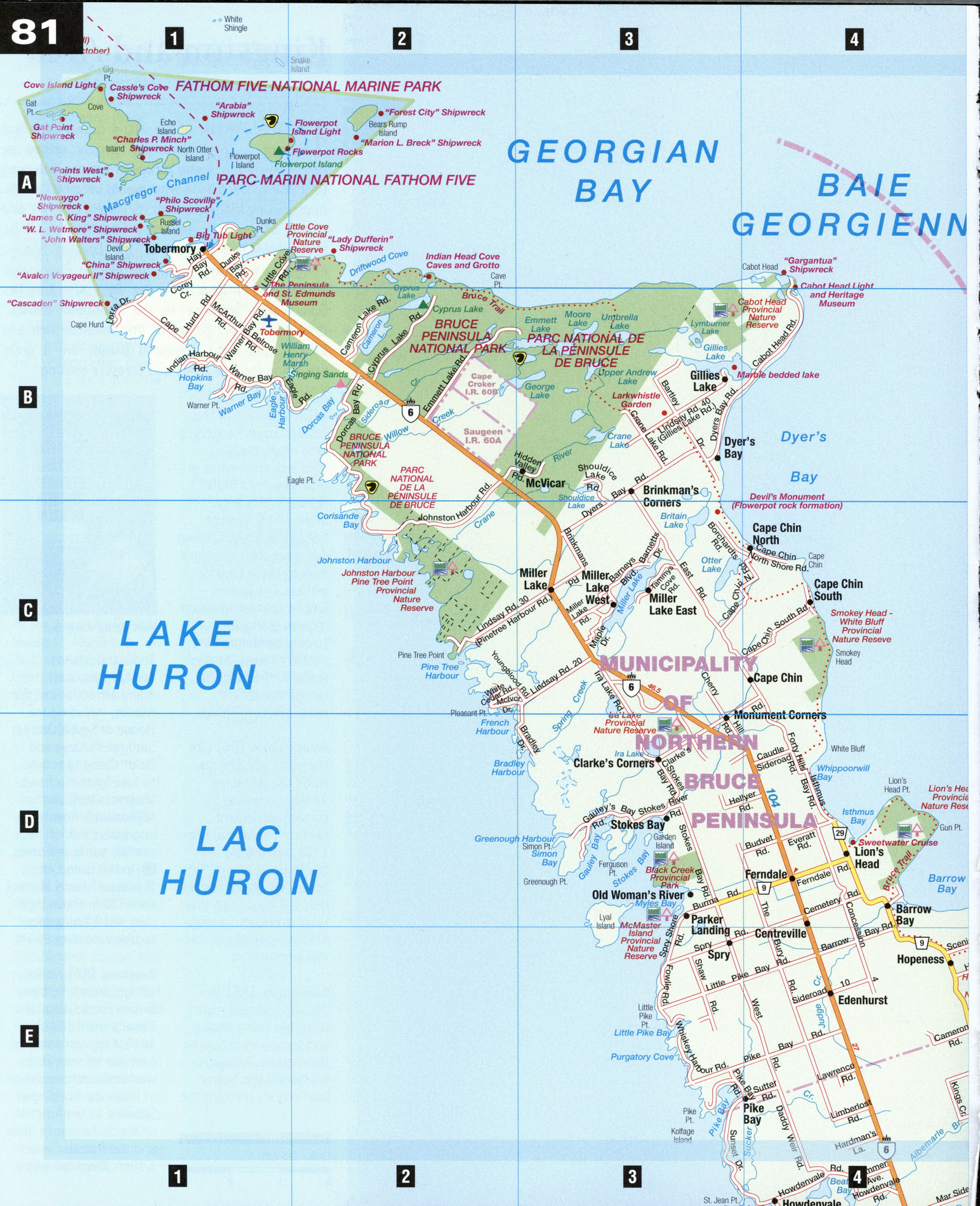
Map of Bruce Peninsula. Detailed map of the highway and local roads of Bruce Peninsula with cities and towns.
Large scale road map of Bruce Peninsula (Canada, Province Ontario)
Map of Bruce Peninsula. Detailed map of the highway and local roads of Bruce Peninsula with cities and towns.
Bruce Peninsula
The tail end of the Niagara Escarpment, the Bruce Peninsula juts northwest into the Great Lakes, carving Georgian Bay out of Lake Huron. The Bruce is an area of great natural beauty where you can hike, bike, walk, swim, canoe, fish, drive, or dive. There are all manner of accommodations, from tepees in Tobermory to cabins and cottages, and unusual sights and attractions, from famous groundhogs to shipwrecks. Beside the escarpment itself, the most widely identified feature in the area is the Bruce Trail, an 800 km hiking trail (with 300 km of side trails) that stretches south along the escarpment from Tobermory to Queenston on the Niagara River.
Bruce Peninsula National Park [B2-B3] has many geological oddities and over 40 species of orchids. The Cyprus Lake area, where many hiking trails lead, not only has beautiful beaches but also interesting rock formations where you can squeeze through arches or climb onto headlands for spectacular views of Georgian Bay. The Singing Sand Beach at Dorcas Bay is shallow enough to walk out for hundreds of meters.
Fathom Five [A1-A2]
Each summer, scuba divers converge on Canada's first national marine park to dive and explore 22 sunken ships. For nondivers, glass-bottomed boats tour the harbors. Boat tours also go to Flowerpot Island, so named because of rock pillars resembling flower pots, created by waves and ice erosion. The tours allow time for sunbathing, diving, spelunking, or hiking along heavily forested trails. Some cedars on the island are 1,000 years old.
Sauble Beach [C7] This popular recreation spot features 12 km of clean sandy beach backed by sand dunes. Sauble Beach Amusements has go-carting, mini-golf, and a roller-skating park. Sauble Trails offers horseback riding and, in the winter, dogsled rides. Stock-car racing is held at the Sauble Speedway Saturday and Sunday nights from May through September. Just north of Sauble Beach, Sauble Falls Provincial Park is an excellent viewpoint for rainbow trout and salmon spawning runs in spring and fall.
Southampton [E6] The oldest port on the Bruce coast is a delightful and tranquil resort community. Windsurfing, tennis, golf, fishing, hiking, or biking the many trails plus a professionally instructed summer art school make "South" an attractive destination. A bird sanctuary and historic lighthouse are on Chantry Island, and at the Bruce County Museum and Archives you can see how furniture and shipbuilding once thrived amid the dense hardwood stands that gave rise to the nickname of the region, Queen's Bush.
Tobermory [Al] The "Underwater Capital of Ontario" recently created a new diving attraction in the bay by sinking the 53 m steel-hulled Niagara II. Tobermory's fishing village charm is enhanced by modern facilities. The harbor is surrounded by bricked walkways, colorful flowerbeds, and a boardwalk from which to view the ferry dock. The Chi-Cheemaun, or "Big Canoe" in Ojibway, is the two-hour ferry link between Tobermory and Manitoulin Island. The area's pioneer and marine history is on display at the Peninsula and St. Edmunds Museum, including shipwreck artifacts and an 1875 furnished log cabin.
Wiarton [B8] Wiarton is the gateway to the Bruce Peninsula as well as "The Groundhog Capital of Canada," (see Local Lore, right). The tourist information center, next to the beach at Bluewater Park, is in the former railway station. Spirit Rock Conservation Area has historic ruins of a grand mansion, wild flowers, and a scenic lookout over Colpoy's Bay. A spiral staircase leads down to the harbor.
LOCAL LORE
Canada's Weather Prognosticator At 8:00 a.m. on July 1, 1999 the ashes of Wiarton's most famous resident were entrusted to the calm waters of Colpoy's Bay. William of Wiarton was better known across Canada as Wiarton Willie, an albino groundhog who was called upon every February 2nd to use his meteorological smarts and prognostication powers to predict if an early spring was in the cards.
His successor, Wee Willie, also an albino groundhog, was discovered in Ottawa and was flown home on April 30, 1999 by Sauble Beach pilot Ross Trask. He made his debut in February of 2000, predicting six more weeks of winter.
Wee Willie lives in a large environmentally safe home located on the front lawn of Wiarton Willy's Motel, under the care of groundhog keeper Sam Brouwer. He favors a regular diet of dried pellets, apples, carrots, and cooked corn, but his favorite treat is said to be wild dandelions. You don't have to wait until February to see Wee Willie: he entertains visitors year-round.